Te Henua Enata – The Marquesas Islands
Te Henua Enata – The Marquesas Islands
Located in the South Pacific Ocean, this mixed serial property bears an exceptional testimony to the territorial occupation of the Marquesas archipelago by a human civilisation that arrived by sea around the year 1000 CE and developed on these isolated islands between the 10th and the 19th centuries. It is also a hotspot of biodiversity that combines irreplaceable and exceptionally well conserved marine and terrestrial ecosystems. Marked by sharp ridges, impressive peaks and cliffs rising abruptly above the ocean, the landscapes of the archipelago are unparalleled in these tropical latitudes. The archipelago is a major centre of endemism, home to rare and diverse flora, a diversity of emblematic marine species, and one of the most diverse seabird assemblages in the South Pacific. Virtually free from human exploitation, Marquesan waters are among the world’s last marine wilderness areas. The property also includes archaeological sites ranging from monumental dry-stone structures to lithic sculptures and engravings.
Description is available under license CC-BY-SA IGO 3.0
Te Henua Enata – Les îles Marquises
Situé dans l’océan Pacifique Sud, ce bien mixte en série constitue un témoignage exceptionnel de l’occupation territoriale de l’archipel des Marquises par une civilisation humaine arrivée par la mer autour de l’an 1000 de notre ère et qui s’est développée sur ces îles isolées entre le Xe et le XIXe siècle. Il s’agit également d’un point chaud de la biodiversité qui combine des écosystèmes marins et terrestres irremplaçables et exceptionnellement bien conservés. Marqués par des crêtes acérées, des pics spectaculaires et des falaises s’élevant abruptement au-dessus de l’océan, les paysages de cet archipel n’ont pas d’équivalent sous ces latitudes tropicales. L’archipel est un important centre d’endémisme, abritant une flore rare et variée, une diversité d’espèces marines emblématiques et l’un des ensembles d’oiseaux marins les plus diversifiés du Pacifique Sud. Pratiquement exemptes d’exploitation humaine, les eaux marquisiennes comptent parmi les dernières zones marines sauvages du monde. Le bien comprend également des sites archéologiques allant de structures monumentales en pierre sèche à des sculptures et gravures lithiques.
Description is available under license CC-BY-SA IGO 3.0
تي هينوا ايناتا - جزر الماركيز
يقف هذا الموقع المختلط المتسلسل في جنوب المحيط الهادي شاهداً استثنائياً على استيطان الحضارة البشرية في أراضي خليج الماركيز بعدما وصلت إليها بحراً بحدود العام 1000 ميلادياً، وأخذت بالازدهار بين القرنَين العاشر والتاسع عشر على هذه الجزر المعزولة. وتمثل هذه الجزر أيضاً موطناً لتنوع بيولوجيّ يضم نظماً بيئية بحرية وبريّة لا غنى عنها وحوفظ عليها بصورة استثنائية. ويتميز هذا الموقع بتضاريسه الجبلية الوعرة، حيث تتناغم القمم المهيبة والمنحدرات الشاهقة التي تباغت الناظرين وترتفع من حيث لا تدري عن سطح المحيط، لترسم لوحةً لا مثيل لها في هذه المناطق الاستوائية. يُعتبر الأرخبيل مركزاً رئيسياً للتوطن ويؤوي نباتات نادرة ومتنوعة، ويحتضن مجموعة متنوعة من الأنواع البحرية الرمزية، كما أنه موطنٌ لأحد أكثر تجمعات الطيور البحرية تنوعاً في جنوب المحيط الهادي. وتعتبر المياه الماركيزية بمنأى نوعاً ما عن الاستغلال البشري، الأمر الذي يجعل منها واحدة من آخر المناطق البرية البحرية في العالم. ويوجد في الموقع أيضاً مواقع أثرية مثل الهياكل الحجرية الضخمة والمنحوتات الصخرية والنقوش.
source: UNESCO/CPE
Description is available under license CC-BY-SA IGO 3.0
人类之地——马克萨斯群岛
source: UNESCO/CPE
Description is available under license CC-BY-SA IGO 3.0
Те Хенуа Эната — Маркизские острова
Этот смешанный серийный объект расположен в южной части Тихого океана. На его территории сохранились уникальные свидетельства того, что Маркизские острова были заселены человеческой цивилизацией, которая около 1000 г. н. э. прибыла сюда морским путем и развивалась на этих изолированных островах с X по XIX век. Это также очаг биоразнообразия, в котором сосредоточены исключительные по ценности и хорошо сохранившиеся морские и наземные экосистемы. Ландшафты архипелага, покрытые острыми хребтами, впечатляющими пиками и скалами, возвышающимися над океаном, не имеют аналогов в этих тропических широтах. Архипелаг является крупным центром эндемизма и домом для редкой и разнообразной флоры, множества ценных морских видов и одного из самых разнообразных скоплений морских птиц в южной части Тихого океана. Благодаря тому, что воды около Маркизских островов практически не подвергаются антропогенной нагрузке, они являются одним из последних в мире морских районов с нетронутой природой. На территории заповедника также находятся археологические памятники — от монументальных каменных сооружений до каменных скульптур и гравировок.
source: UNESCO/CPE
Description is available under license CC-BY-SA IGO 3.0
Te Henua Enata - Las islas Marquesas
Este conjunto de sitios mixto, ubicado en el océano Pacífico Sur, constituye un testimonio excepcional de la ocupación territorial del archipiélago de las Marquesas por una civilización humana que llegó por mar en torno al año 1000 e. c., y se desarrolló en estas islas aisladas entre los siglos X y XIX. También es una región clave para la biodiversidad que combina ecosistemas marinos y terrestres irreemplazables y excepcionalmente bien conservados. Los paisajes del archipiélago, que están marcados por crestas afiladas, picos impresionantes y acantilados que se elevan abruptamente sobre el océano, no tienen parangón en estas latitudes tropicales. El archipiélago también constituye un centro importante de endemismo, albergando una flora diversa y única, una gran variedad de especies marinas emblemáticas y una de las agrupaciones de aves marinas más diversas del Pacífico Sur. Las aguas marquesanas, prácticamente libres de explotación humana, se encuentran entre las últimas áreas silvestres marinas del mundo. El sitio también incluye yacimientos arqueológicos que abarcan desde estructuras monumentales de piedra seca a esculturas y grabados líticos.
source: UNESCO/CPE
Description is available under license CC-BY-SA IGO 3.0

Outstanding Universal Value
Brief synthesis
Located in the heart of the South Pacific Ocean, the Marquesas Islands are among the most geographically isolated archipelagos in the world. The islands' dramatic landscapes feature steep mountains, towering cliffs, and cloud-covered peaks descending into deep valleys. Te Henua Enata – The Marquesas Islands is a serial property comprising seven distinct sites, each bearing exceptional testimony to the settlement and territorial occupation of the Marquesas by a seafaring civilization that arrived around 1000 CE. This society flourished in isolation for centuries before European contact and the subsequent annexation of the archipelago by France in 1842.
Throughout this period, the Ènata—meaning "human beings" in Marquesan—developed a sophisticated social structure based on chiefdoms, establishing settlements in valleys that stretched from the ridges down to the coastline and the sea. These valleys served as both spatial and symbolic units of governance. Owing to demographic decline and the abandonment of many ancient settlements, numerous archaeological remains have been preserved, often hidden beneath dense forest cover.
This serial property is recognized as a biodiversity hotspot for both terrestrial and marine life in the Pacific. The Marquesas rank first or second worldwide in terms of endemic species, including vascular plants, land and seabirds, terrestrial and marine molluscs, and freshwater fish. These species inhabit a wide range of natural environments, from coastal formations to scrublands high on ridges that can exceed 1,000 metres in altitude. Lacking the coral reefs typically found in this type of oceanic island in the eastern Pacific, the waters of the Marquesas Islands are an exceptional example of a tropical island ecosystem with very high primary productivity. Notable for their high endemism of coastal fish and marine molluscs, the waters of the Marquesas archipelago have been described as the wildest coastal marine province in the world. The archipelago sustains some of the world's highest coastal biomass levels, dominated by apex predators. The marine ecosystem is virtually free from human exploitation. The archipelago also boasts a wide variety of emblematic marine species, including rays, dolphins and nesting seabirds. The relatively undisturbed ecological processes of the Marquesas provide a unique model of species evolution in an oceanic island environment.
Criterion (iii): Te Henua Enata – The Marquesas Islands provide an outstanding example of the Ènata's occupation from the 10th to the 19th century, offering insight into their adaptation to a challenging natural environment with limited building materials, their settlement patterns in deep, rugged valleys, and their complex social and spiritual organization into chiefdoms. The steep volcanic terrain and climatic constraints led the Ènata to construct two-storey dry-stone lithic platforms (paepae), some of which rise up to six metres in height, serving as both housing and ceremonial buildings, including tohua (gathering places) and me’ae (sacred spaces). The local people also developed a unique art form, incorporating sculpted tiki figures and intricate petroglyph engravings, illustrating the close relationship between human beings and their environment. The eight valleys within the property are considered the most remarkable for the density and size of their lithic remains.
Criterion (vi): Despite the near disappearance of the Ènata following the demographic collapse and cultural assimilation caused by European contact, many tales, myths, and legends referring to real and cosmological landscapes remain alive today, passed down in the Marquesan language. Combined with the knowledge handed down from generation to generation, the writings of the early explorers from the late 18th and 19th centuries, and the first ethnographic studies carried out in the late 19th century, they provide valuable insights into the life of the Ènata chiefdoms, including their belief systems surrounding the origins of the world. All these living traditions and knowledge highlight the enduring connection the modern Marquesan population have with their environment.
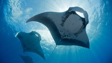
Criterion (vii): The Marquesas’ volcanic origins have created dramatic landscapes of razor-sharp ridges, towering peaks, and sheer cliffs rising over 1,000 metres above the ocean. The Marquesas are among the world's most "vertical" islands. Their lush vegetation, combined with dramatic topography and rugged coastlines, creates island scenery unparalleled in the tropics. The cliffs plunge directly into the ocean, providing natural vantage points for observing wildlife, including hundreds of dolphins gathering in massive pods, alongside two species of manta rays—the reef manta ray and the giant manta ray—whose rare microsympatry (shared habitat at the same dive site) is highly unusual and rarely observed elsewhere in the world. This creates a breathtaking panorama of raw, untamed nature.
Criterion (ix): The Marquesas, the only isolated archipelago in the middle of the equatorial Pacific, are an oasis of marine life in the vast Pacific Ocean. The counter-current surrounding the Marquesas isolates the property from the main oceanic currents. The archipelago has one of the world's highest fish biomasses, averaging 3.30 T/ha with peaks of 20 T/ha. Marquesan waters exhibit exceptional endemism relative to their size (3,400 km²), with 13.7% of coastal fish and 10% of mollusc species found nowhere else. Marquesan coastal communities are a major centre of Indo-Pacific and global endemism, along with Hawaii, Easter Island and the Red Sea. Recognized as one of the last remaining wild marine areas on the planet, the Marquesas' waters harbour some of the best-preserved coastal ecosystems worldwide. On land, the property protects two continuous vegetation corridors from summit to shore and includes four distinct tropical cloud forest ecosystems.
Criterion (x): The property harbours exceptionally well-preserved and irreplaceable marine and terrestrial ecosystems. The isolation of the young volcanic islands of the Marquesas archipelago has given rise to rare and diverse plant life, and more than half of the property's 305 plant species are irreplaceable. Endemism is particularly high in dry and semi-dry coastal forests, as well as in the mesic and ombrophilous forests of the highlands. The cloud forests that cover the ridges and peaks of the islands of Nuku Hiva, Ua Pou, Tahuata and Fatu Iva are home to over 70% of the endemic species of a peak, island or archipelago. The majority of land and freshwater molluscs are endemic to the islands. The archipelago supports one of the most diverse assemblages of seabirds in the tropical waters of the South Pacific. It is one of the world's few known nesting sites for 21 species of seabirds and 13 species and subspecies of land birds endemic to the archipelago. Fatu Iva and Tahuata are home to two endangered endemic species: respectively the òmaò keekee, with around 30 individuals, and the pahi, estimated at fewer than 300 individuals in 2017. The property is home to many endangered species such as the pītai, ùpe and kōtuè. The coastal marine ecosystem supports 40 notable species, many of which are globally endangered, including 16 marine mammals, 26 species of rays and sharks, and one endangered sea turtle, all concentrated around the 12 islands of the archipelago. Over 40% of fish species are endemic to the ecoregion, inhabiting a range of shoal areas, marine, brackish, and freshwater environments.
Integrity
The valley was the territorial unit of the chiefdoms, and the boundaries of the constituent elements of Te Henua Enata – The Marquesas Islands reflect this by including the entire valley territory, from the top of the ridges down to the coastline and adjacent marine areas, with the exception of modern settlement areas, which are included in the buffer zone.
Taken as a whole, the seven components provide a comprehensive representation of the Ènata way of life and the territorial, spatial, social and spiritual organization of their societies up to the 19th century. The abandonment of the ancient settlements has shielded them from human activity, preserving their archaeological remains in situ.
Only certain sites in the Hatiheu, Taaoa and Puamau valleys have been cleared and restored. The restoration of certain tohuas for festivals (Matavaa) was an opportunity to return them to their original use as public spaces for traditional celebrations and events. Most archaeological sites remain protected due to their remoteness and dense vegetation cover. However, the proliferation of invasive plant species, such as acacia and Java plum trees, has affected the legibility and structural integrity of some sites, with some stones being displaced by tree roots. Feral animals are also causing erosion.
The impacts of climate change, including a gradual rise in sea level and increasingly frequent and prolonged droughts, have already been observed and are expected to intensify in the future, along with other unforeseen consequences.
The archipelago's island and seascape are virtually untouched, and the small human population is concentrated along the coast. Eighty-eight percent of the archipelago's plant diversity is represented within the property. The property also includes 100% of the seabird diversity—21 nesting species—and 78% of the land bird diversity. All the watersheds and major rivers are included within the property, while 91% of freshwater fish and crustacean species are represented. The plant formations are well preserved but highly vulnerable to biological invasion. The most significant plant species threatening the site’s integrity include Falcata, Miconia, Acacia, and the African tulip tree. Agricultural activities, along with roaming animals and uncontrolled fires, exert pressure at mid-altitude, which must be managed locally. The least disturbed ecosystems of the Marquesas are found at altitudes between 800 and 1,200 m.
The property protects all coastal waters that support the life cycle of seabirds, coastal fish, molluscs and 43 notable marine species that reside in or visit these waters. Recognized as the world's most pristine coastal marine province, the Marquesas' waters exhibit exceptional food web integrity, with remarkable coastal fish biomass and an unusually high proportion of top predators. The effects of climate change on species distribution, life traits, and life cycles remain unpredictable. The property includes the entire length of the archipelago's four richest rivers, as well as two continuous vegetation corridors, ensuring essential functions for species life cycles and facilitating their adaptation.
Authenticity
Most of the archaeological sites in Te Henua Enata – The Marquesas Islands have not undergone prior interventions or restoration, leaving them entirely authentic in form, design, materials, and substance. Previous restoration efforts targeting certain archaeological sites, in part motivated by the Marquesas Islands Arts and Culture Festival (Matavaa o te Henua Ènana), were mostly conducted under professional supervision.
The spirit and atmosphere of the sites where the archaeological remains are located, along with their tangible reflection of ancestral activities, are still deeply felt by contemporary Marquesans. Despite the demographic shock and the acculturation to European traditions and practices, the oral transmission of stories, myths and legends within families, combined with the writings by early visitors and the ethnographic studies undertaken in the late 19th century, has preserved important knowledge about the history and social significance of these places.
Protection and management requirements
A complete inventory of archaeological remains and the designation of key sites as historical monuments under the Polynesian Heritage Code are essential conditions for the protection and management of the site. The General Development Plan (PGA), that applies to the entire territory of the six municipalities of the Marquesas Islands is essential for setting landscape regulations, both for the property and the buffer zones. Special regulatory requirements for the property and the buffer zone will be incorporated into the PGA, in line with the commitments made by the six Marquesas municipalities within the Communauté de Communes des Îles Marquises (CODIM) and the French Polynesian authorities. Effective management planning must also be ensured by integrating the provisions of the General Development Plan with those of the property management plan.
Governance of the property is shared by a management committee, co-chaired by the French Polynesian Minister of Culture, Environment, and Marine Resources, along with the Community of Municipalities of the Marquesas Islands (CODIM). Day-to-day management is delegated to a coordination unit responsible for implementing the management plan, centralizing information and coordinating actions, as well as coordinating the network of six local World Heritage associations (one per island), among other tasks. Appropriate financial and human resources are needed to ensure that the coordination unit can fulfil its mandate and responsibilities.
Regular maintenance and vegetation control of the architectural sites are critical to preventing structural degradation and mitigating climate-related risks. A comprehensive strategy for invasive species management is required, incorporating prevention, early detection, and eradication measures to safeguard the site’s cultural and natural values. Additionally, efforts to promote sustainable agricultural practices near the property, limit fire outbreaks, and restrict access for roaming animals will contribute to long-term conservation of the property.
Long-term conservation and management expectations for the serial property depend on integrating cultural and natural heritage into the management system. This includes recognizing the interdependence of cultural and natural values, identifying attributes reflecting this interdependence, establishing a joint program to monitor conservation status, integrating cultural and natural significance in interpretation and enhancement efforts, fostering institutional collaboration, and ensuring participatory decision-making processes. The effectiveness of this integrated management system must be assessed and improved over time.
The sites classified under the Environment Code include two Category V protected landscapes (Hohoi Bay on Ua Pou and Hanavave Bay on Fatu Iva) and two Category IV habitat and species management areas (Eiao and Hatu Tu). All Polynesian waters are a sanctuary for marine mammals and all shark species. Industrial fishing is prohibited within the property. Species protection regulations prohibit the harvesting of species from their natural environment and the alteration of their natural habitat. These regulations cover 164 plant species, 39 bird species, all marine mammals, sharks, rays and sea turtles, as well as certain terrestrial and marine molluscs. The sectors of fishing, agriculture, and biosecurity also include regulatory protections, particularly concerning pesticide reduction or prohibition and strengthened efforts against invasive exotic species.
The strategy to combat invasive species is a shared priority for preserving the property's cultural and natural values. It includes measures to prevent their introduction and spread, as well as early detection and eradication measures. Environmental impact assessments should include an analysis of the potential impact on the integrity and authenticity of the property. In agricultural areas adjacent to the property, management efforts will focus on promoting sustainable agricultural practices, limiting and containing fire outbreaks, and restricting areas accessible to roaming animals. Planning regulations and conservation measures may be enhanced based on the inventory of scenic viewpoints, key archaeological sites, property access points, and visitor centres.
For local management of the property, World Heritage Associations will be created in each of the archipelago's six municipalities, to support the involvement of local residents, associations and professionals. Alongside the actions undertaken by the country’s technical departments, these associations participate in implementing the operational aspects of the management plan, whose strategic guidelines are defined by the management committee, co-chaired by the Minister of Culture, Environment, and Marine Resources of French Polynesia and the President of CODIM. The management structure is jointly led by the Ministry, CODIM, and the six World Heritage associations through a coordination unit. Participatory governance of the property is essential to ensure that the management plan is firmly rooted at the local level and to benefit from the effectiveness of traditional practices.

The Nomination files produced by the States Parties are published by the World Heritage Centre at its website and/or in working documents in order to ensure transparency, access to information and to facilitate the preparations of comparative analysis by other nominating States Parties.
The sole responsibility for the content of each Nomination file lies with the State Party concerned. The publication of the Nomination file, including the maps and names, does not imply the expression of any opinion whatsoever of the World Heritage Committee or of the Secretariat of UNESCO concerning the history or legal status of any country, territory, city or area or of its boundaries.