Print
Share on social media
Facebook TwitterUNESCO social media
Facebook Youtube Twitter RSS World Heritage Terms / Policies SyndicationArchaeological Border complex of Hedeby and the Danevirke
Multiple Locations (22)
| ID | Name & Location | State Party | Coordinates | Property | Buffer Zone |
|---|---|---|---|---|---|
| 1553-001 | Crooked Wall Area 4 | Germany |
N54 27 20.3 E9 20 48.6 |
1.4 ha | 0 ha |
| 1553-002 | Crooked Wall Areas 3 to 4 | Germany |
N54 27 53.9 E9 23 11.7 |
16.1 ha | |
| 1553-003 | Crooked Wall Areas 1 to 2 Main Wall Areas 4 to 5 | Germany |
N54 27 43 E9 27 14.8 |
25.2 ha | |
| 1553-004 | Main Wall Areas 2 to 3 | Germany |
N54 28 41.7 E9 29 20.6 |
14.4 ha | |
| 1553-005 | Main Wall Area 1 | Germany |
N54 29 14.1 E9 30 10.6 |
6.3 ha | |
| 1553-006 | Connection Wall Area 9 North Wall Area 4 Arched Wall | Germany |
N54 29 37.4 E9 30 43.1 |
3.6 ha | |
| 1553-007 | North Wall Areas 1 to 2 | Germany |
N54 29 57 E9 31 24.6 |
3.6 ha | |
| 1553-008 | Arched Wall | Germany |
N54 29 39.5 E9 31 08.3 |
0.8 ha | |
| 1553-009 | Connection Wall Area 8 | Germany |
N54 29 35.7 E9 31 04.3 |
2.5 ha | |
| 1553-010 | Connection Wall Areas 5 to 7 | Germany |
N54 29 30.5 E9 32 06.9 |
5.8 ha | |
| 1553-011 | Connection Wall Area 3 | Germany |
N54 29 26 E9 33 10.4 |
0.6 ha | |
| 1553-012 | Hedeby | Germany |
N54 29 28 E9 33 59 |
95 ha | |
| 1553-013 | Kovirke Area 1 | Germany |
N54 27 46.9 E9 28 41.5 |
0.9 ha | |
| 1553-014 | Kovirke Area 2 | Germany |
N54 27 50.1 E9 29 05.1 |
0.3 ha | |
| 1553-015 | Kovirke Area 3 to 5 | Germany |
N54 28 05.4 E9 31 03.8 |
7.9 ha | |
| 1553-016 | Kovirke Area 6 | Germany |
N54 28 25.2 E9 33 34.1 |
2.1 ha | |
| 1553-017 | Kovirke Area 7 | Germany |
N54 28 27.6 E9 33 58.6 |
0.05 ha | |
| 1553-018 | Kovirke Area 8 | Germany |
N54 28 30.1 E9 34 16.6 |
0.5 ha | |
| 1553-019 | Offshore Work | Germany |
N54 30 53.6 E9 38 28.9 |
36.2 ha | |
| 1553-020 | East Wall Area 1A to 1C | Germany |
N54 28 51.3 E9 44 49.1 |
1.9 ha | 0 ha |
| 1553-021 | East Wall Area 2D | Germany |
N54 28 34.9 E9 46 23.8 |
0.5 ha | |
| 1553-022 | East Wall Area 2E to 2F | Germany |
N54 28 35.9 E9 46 57.9 |
1.9 ha |
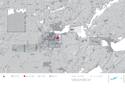
Maps
| Date | Title | |
|---|---|---|
|
2018 | Archaeological Border complex of Hedeby and the Danevirke - Map of the Inscribed Property |
Disclaimer
The Nomination files produced by the States Parties are published by the World Heritage Centre at its website and/or in working documents in order to ensure transparency, access to information and to facilitate the preparations of comparative analysis by other nominating States Parties.
The sole responsibility for the content of each Nomination file lies with the State Party concerned. The publication of the Nomination file, including the maps and names, does not imply the expression of any opinion whatsoever of the World Heritage Committee or of the Secretariat of UNESCO concerning the history or legal status of any country, territory, city or area or of its boundaries.