Kujataa Greenland: Norse and Inuit Farming at the Edge of the Ice Cap
Multiple Locations (5)
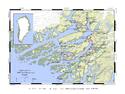
| ID | Name & Location | State Party | Coordinates | Property | Buffer Zone |
|---|---|---|---|---|---|
| 1536-001 | Qassiarsuk | Denmark |
N61 9 52 W45 35 53 |
11.342 ha | 7.703 ha |
| 1536-002 | Igaliku | Denmark |
N61 0 6 W45 22 29 |
8.287 ha | 49.524 ha |
| 1536-003 | Sissarluttoq | Denmark |
N60 53 48 W45 29 42 |
339 ha | |
| 1536-004 | Tasikuluulik (Vatnahverfi) | Denmark |
N60 50 52 W45 23 24 |
7.542 ha | |
| 1536-005 | Qaqortukulooq (Hvalsey) | Denmark |
N60 47 33 W45 50 4 |
7.382 ha |
Disclaimer
The Nomination files produced by the States Parties are published by the World Heritage Centre at its website and/or in working documents in order to ensure transparency, access to information and to facilitate the preparations of comparative analysis by other nominating States Parties.
The sole responsibility for the content of each Nomination file lies with the State Party concerned. The publication of the Nomination file does not imply the expression of any opinion whatsoever of the World Heritage Committee or of the Secretariat of UNESCO concerning the history or legal status of any country, territory, city or area or of its boundaries.