Landscapes of Dauria
Multiple Locations (5)
| ID | Name & Location | State Party | Coordinates | Property | Buffer Zone |
|---|---|---|---|---|---|
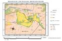
| 1448rev-001 | Forest steppe part of Daursky SNBR | Russian Federation |
N50 21 46 E115 17 13 |
300 ha | 3,958 ha |
| 1448rev-002 | Daursky SNBR and Valley of Dzeren Nature Refuge | Russian Federation |
N50 11 50 E116 0 0 |
278,723 ha | 124,930 ha |
| 1448rev-002 | Mongol Daguur SPNA | Mongolia |
N49 49 45.99 E115 4 2.99 |
580,080 ha | 178,429 ha |
| 1448rev-003 | Chuh-Nuur Lake cluster | Mongolia |
N49 32 47 E114 38 28 |
7,361 ha | |
| 1448rev-004 | Ugtam Nature refuge | Mongolia |
N49 15 60 E113 45 00 |
46,160 ha | — |
Maps
| Date | Title | |
|---|---|---|
|
2017 | Landscapes of Dauria - Maps of the inscribed property |
Disclaimer
The Nomination files produced by the States Parties are published by the World Heritage Centre at its website and/or in working documents in order to ensure transparency, access to information and to facilitate the preparations of comparative analysis by other nominating States Parties.
The sole responsibility for the content of each Nomination file lies with the State Party concerned. The publication of the Nomination file, including the maps and names, does not imply the expression of any opinion whatsoever of the World Heritage Committee or of the Secretariat of UNESCO concerning the history or legal status of any country, territory, city or area or of its boundaries.