Shushtar Historical Hydraulic System
Shushtar Historical Hydraulic System
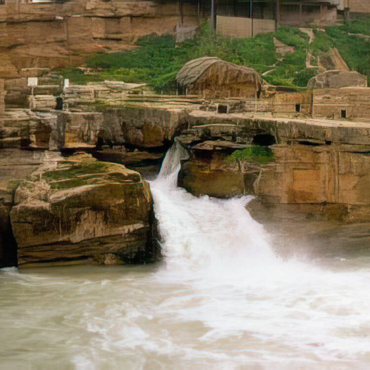
Shushtar, Historical Hydraulic System, inscribed as a masterpiece of creative genius, can be traced back to Darius the Great in the 5th century B.C. It involved the creation of two main diversion canals on the river Kârun one of which, Gargar canal, is still in use providing water to the city of Shushtar via a series of tunnels that supply water to mills. It forms a spectacular cliff from which water cascades into a downstream basin. It then enters the plain situated south of the city where it has enabled the planting of orchards and farming over an area of 40,000 ha. known as Mianâb (Paradise). The property has an ensemble of remarkable sites including the Salâsel Castel, the operation centre of the entire hydraulic system, the tower where the water level is measured, dams, bridges, basins and mills. It bears witness to the know-how of the Elamites and Mesopotamians as well as more recent Nabatean expertise and Roman building influence.
Description is available under license CC-BY-SA IGO 3.0
Système hydraulique historique de Shushtar
Le système hydraulique historique de Shushtar a été inscrit en tant que chef d’œuvre du génie créateur humain. Il aurait été entrepris dès Darius le Grand, au Vème siècle av. J.-C. Il s’agit de deux grands canaux de dérivation des eaux de la rivière Kârun. L’un d’entre eux, le canal Gargar, fournit encore de l’eau à la ville de Shustar par une série de tunnels et fait fonctionner tout un ensemble de moulins. Après une falaise spectaculaire, l’eau tombe en cascades dans le bassin aval, avant d’entrer dans la plaine au sud de la ville, où elle a permis le développement de vergers et de terres agricoles sur une surface de 40 000 ha. dénommée Mianaâb (Le paradis). Le bien comprend des lieux remarquables, dont le château Salâsel, centre de contrôle de tout le système hydraulique, la tour Kolâh-Farangi qui mesure le niveau de l’eau, des barrages, ponts, bassins et moulins. Il témoigne du savoir-faire des Elamites et Mésopotamiens, ainsi que de l’expertise plus récente des Nabatéens et de l’influence du génie civil romain.
Description is available under license CC-BY-SA IGO 3.0
منظومة شوشتار الهيدرولية التاريخية
منظومة شوشتار الهيدرولية التاريخية ـ جسور، وسدود، وقنوات، ومبانٍ، وطواحين ماء من قديم الزمان إلى اليوم (إيران) ـ يُمكن تتبع تاريخ هذا الممتلك، الذي يُمثل إحدى روائع العقل البشري المبدع، إلى عهد داريوس الكبير في القرن الخامس قبل الميلاد. ويضم الممتلك قناتي تحويل رئيستين تقعان على نهر قارون، لا زالت إحداها، وهي قناة جارجار، تُستخدم حتى الآن لتوفير المياه لمدينة شوشتار، وذلك عن طريق سلسلة من الأنفاق التي تدير الطواحين. ويُشكل الممتلك منحدراً رائع المنظر يحوي شلالات مياه تصب في حوض مجرى النهر. ومن ثم يتم روي السهل الواقع في جنوب المدينة حيث أمكن زرع أشجار البساتين وزارعة منطقة تبلغ مساحتها 40.000 هكتار، وهي منطقة تُعرف باسم "مياناب" (الفردوس). ويشمل الممتلك مجموعة من المواقع الرائعة، من بينها قلعة سالاسيل، والمركز التشغيلي للمنظومة الهيدرولية بأكملها، والبرج الذي يُقاس فيه منسوب المياه، وسدود، وجسور، وأحواض وطواحين. ويشهد الممتلك على المهارات التي كان يتمتع بها الإيلاميون والسكان الأصليون لبلاد ما بين النهرين، وعلى ما جاء بعد ذلك من الخبرات النبطية وتأثيرات العمارة الرومانية.
source: UNESCO/CPE
Description is available under license CC-BY-SA IGO 3.0
Sistema hidráulico histórico de Shushtar
Puentes, presas, canales, construcciones y molinos de agua del pasado y el presente, inscrito como obra maestra del ingenio creativo, se remonta a los tiempos de Darío el Grande (siglo V a.C.) con la creación de dos canales principales de desviación de las aguas del río Kârun. Uno de ellos, el canal de Gargar, todavía abastece de agua a la ciudad de Shushtar, atravesando toda una red de túneles y haciendo funcionar un conjunto de molinos hidráulicos. Desde un farallón espectacular, el agua cae en cascada hacia un estanque situado en la parte baja, antes de entrar en la llanura situada al sur de la ciudad donde riega un terreno de 40.000 hectáreas de campos y huertos de árboles frutales conocido por el nombre de Mianâb (el Paraíso). El sitio comprende también un conjunto de construcciones notables como el castillo de Salâsel, centro de control de todo el sistema hidráulico, la torre de Kolâh-Farangi, que mide el nivel del agua, y toda una serie de presas, puentes estanques y molinos hidráulicos. Este sitio es un testimonio del saber teórico y práctico de los antiguos elamitas y los pueblos mesopotámicos, de los conocimientos técnicos de la civilización nabatea posterior y de la influencia de la ingeniería civil del Imperio Romano.
source: UNESCO/CPE
Description is available under license CC-BY-SA IGO 3.0
シューシュタルの歴史的水利施設
創造的才能の傑作として価値が認められたこの水利施設は、紀元前5世紀のダリウス1世の時代に造られた。カールーン川の2つの主要な運河を含み、そのひとつギャルギャル運河は、製粉場に通じるトンネルを抜け、いまもシューシュタル市に水を供給している。運河は壮観な崖を成し、トンネルを抜けた水は滝のように下流に向かって流れ落ち、市南部の平野に至って4万haもの農場と果樹園を潤している。この遺産はサラセル城、水利システムの操作場、水位を測る塔、ダム、ため池、水車場などから成る。エラムやメソポタミアの人びとの技術を受け継ぎ、いまではナバテアの人びとの技術やローマ由来の建築技術の影響までうかがい知ることができる。source: NFUAJ
Historisch hydraulisch systeem van Shushtar
Het hydraulisch systeem van Shushtar staat te boek als meesterwerk van een creatief genie en is terug te voeren naar Darius de Grote in de 5e eeuw voor Christus. Het systeem omvat twee gecreëerde afvoerkanalen in de rivier Karun. Een daarvan – het Gargar kanaal – wordt nog steeds gebruikt als waterverstrekking voor de stad Shushtar, via een reeks tunnels die water aan molens leveren. De tunnels vormen een spectaculaire klif van waaruit water valt in een stroomafwaarts bassin. Daarna vloeit het over in een 40.000 hectare groot gebied ten zuiden van de stad, waar het de aanplant van boomgaarden en landbouw ondersteunt.
Source: unesco.nl
Outstanding Universal Value
Brief Synthesis
The Shushtar Historical Hydraulic System demonstrates outstanding universal value as in its present form, it dates from the 3rd century CE, probably on older bases from the 5th century BCE. It is complete, with numerous functions, and large-scale, making it exceptional. The Shushtar system is a homogeneous hydraulic system, designed globally and completed in the 3rd century CE. It is as rich in its diversity of civil engineering structures and its constructions as in the diversity of its uses (urban water supply, mills, irrigation, river transport, and defensive system). The Shushtar Historical Hydraulic System testifies to the heritage and the synthesis of earlier Elamite and Mesopotamian knowhow; it was probably influenced by the Petra dam and tunnel and by Roman civil engineering. The Shushtar hydraulic system, in its ensemble and most particularly the Shâdorvân Grand Weir (bridge-dam), has been considered a Wonder of the World not only by the Persians but also by the Arab-Muslims at the peak of their civilisation. The Gargar canal is a veritable artificial watercourse which made possible the construction of a new town and the irrigation of a vast plain, at the time semi-desert. The Shushtar Historical Hydraulic System sits in an urban and rural landscape specific to the expression of its value.
Criterion (i): The Shushtar Hydraulic System is testimony to a remarkably accomplished and early overall vision of the possibilities afforded by diversion canals and large weir-dams for land development. It was designed and completed in the 3rd century CE for sustainable operation and is still in use today. It is a unique and exceptional ensemble in terms of its technical diversity and its completeness that testifies to human creative genius.
Criterion (ii): The Shushtar Historical Hydraulic System is a synthesis of diverse techniques brought together to form a remarkably complete and large-scale ensemble. It has benefited from the ancient expertise of the Elamites and Mesopotamians in canal irrigation, and then that of the Nabateans; Roman technicians also influenced its construction. Its many visitors marvelled at it and were in turn inspired. It testifies to the exchange of considerable influences in hydraulic engineering and its application throughout antiquity and the Islamic period under the various Iranian dynasties.
Criterion (v): Shushtar is a unique and exceptionally complete example of hydraulic techniques developed during ancient times to aid the occupation of semi-desert lands. By diverting a river flowing down the mountains, using large-scale civil engineering structures and the creation of canals, it made possible multiple uses for the water across a vast territory: urban water supply, agricultural irrigation, fish farming, mills, transport, defence system, etc. It testifies to a technical culture dating back eighteen centuries serving the sustainable development of a human society, in harmony with its natural and urban environment.
Integrity and Authenticity
The integrity of the hydraulic footprint is good, but its functional integrity compared with the original model is only partial and reduced, notably for the dams; it remains good for irrigation and water supply. The authenticity of elements reduced to archaeological remains is certain, but has been affected by 20th century works and materials so far as the civil structures and sites still in use are concerned. Efforts directed to the restoration of attributes that demonstrate authenticity must be pursued.
Management and protection requirements
The components of the management plan are satisfactory, but they need to be improved in terms of the interpretation of the sites and the involvement of the local population.


