Ruins of Loropéni
Ruins of Loropéni
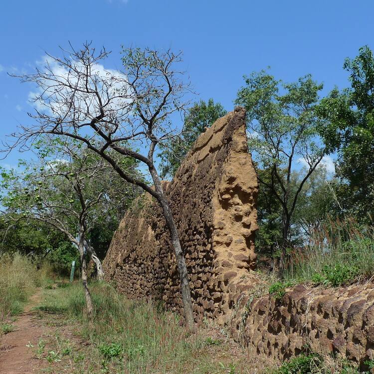
The 11,130m2 property, the first to be inscribed in the country, with its imposing stone walls is the best preserved of ten fortresses in the Lobi area and is part of a larger group of 100 stone enclosures that bear testimony to the power of the trans-Saharan gold trade. Situated near the borders of Côte d’Ivoire, Ghana and Togo, the ruins have recently been shown to be at least 1,000 years old. The settlement was occupied by the Lohron or Koulango peoples, who controlled the extraction and transformation of gold in the region when it reached its apogee from the 14th to the 17th century. Much mystery surrounds this site large parts of which have yet to be excavated. The settlement seems to have been abandoned during some periods during its long history. The property which was finally deserted in the early 19th century is expected to yield much more information.
Description is available under license CC-BY-SA IGO 3.0
Ruines de Loropéni
Ce premier site burkinabé est bardé de hauts murs et s’étend sur 11 130 m2. C’est la mieux préservée des dix forteresses que compte la région du Lobi. Il s’inscrit aussi dans un ensemble plus large qui compte une centaine d’enceintes en pierre, reflétant la puissance du commerce transsaharien de l’or. Vieilles d’au moins mille ans selon des découvertes récentes, ces ruines sont situées près des frontières du Togo et du Ghana. L’emplacement a été occupé par les Lohron ou les Koulango qui contrôlaient l’extraction et la transformation de l’or dans la région à l’apogée de cette exploitation aurifère (XIVème au XVIIème siècle). Beaucoup de mystère entoure ce site dont une large part n’a pas encore été fouillée. Au cours de sa longue histoire, Loropéni semble avoir été abandonné à plusieurs reprises. L’abandon définitif est intervenu entre le début et le milieu du XIXème siècle. Ce site promet encore beaucoup d’informations.
Description is available under license CC-BY-SA IGO 3.0
أطلال لوروبيني
أطلال لوروبيني (بوركينا فاسو) ـ من بين الحصون العشرة الواقعة في منطقة لوبي، بقي هذا الممتلك ذو الجدران الضخمة، الذي تبلغ مساحته 130. 11 متر مربع، في أفضل صورة له؛ وهو يُشكل جزءاً من مجموعة واسعة تتكون من 100 سور حجري التي تدل على ازدهار تجارة الذهب العابرة للصحراء. وقد دلت شواهد حديثة على أن تاريخ هذه الأطلال، الواقعة بالقرب من حدود الكوت ديفوار وغانا وتوغو، يعود إلى ما لا يقل عن 1000 سنة. وقد احتلت قبائل لوهرون أو كولانغو هذا الموقع، وسيطرت على عمليات استخراج وتحويل الذهب فيه أثناء فترة ازدهاره التي استمرت من القرن الرابع عشر إلى القرن السابع عشر. ويكتنف كثير من الغموض الموقع الذي بقيت أجزاء شاسعة منه بمنأى عن الحفريات الأثرية. ومن الواضح أن الموقع ظل مهجوراً في بعض الفترات من تاريخه الطويل. ومن المتوقع أن يتوافر المزيد من المعلومات بشأن هذا الممتلك الذي هجره سكانه بصفة نهائية في أوائل القرن التاسع عشر.
source: UNESCO/CPE
Description is available under license CC-BY-SA IGO 3.0
Ruinas de Loropeni
Este sitio de 11.130 m2 es el primero de Burkina Faso que ingresa en la Lista. En él se hallan los impresionantes muros de piedra de la mejor conservada de las diez fortalezas existentes en la zona de Lobi. Es parte integrante de un conjunto más amplio de cien recintos de piedra que atestiguan la importancia del comercio del oro a través del Sahara. Recientemente se ha podido comprobar que la ruinas de esta edificación, situadas cerca de las fronteras con Côte d’Ivoire, Togo y Ghana, tienen diez siglos de antigüedad como mínimo. Este asentamiento humano fue ocupado por los pueblos lohron y kulango que controlaban la extracción y transformación del oro en la región durante el periodo de apogeo de ésta, entre los siglos XIV y XVII. Existen muchas incógnitas sobre el sitio, debido a que todavía no se han efectuado excavaciones en una gran parte del mismo. Parece ser que sus habitantes lo desertaron en algunos periodos de su secular historia, hasta abandonarlo definitivamente a principios del siglo XIX. Se espera que las excavaciones futuras proporcionen mucha más información.
source: UNESCO/CPE
Description is available under license CC-BY-SA IGO 3.0
ロロペニの遺跡
source: NFUAJ
Loropéni ruïnes
Source: unesco.nl
Outstanding Universal Value
Brief synthesis
The dramatic and memorable Ruins of Loropéni consist of imposing, tall, laterite stone perimeter walls, up to six metres in height, surrounding a large abandoned settlement. As the best preserved of ten similar fortresses in the Lobi area, part of a larger group of around a hundred stone-built enclosures, they are part of a network of settlements that flourished at the same time as the trans-Saharan gold trade and appear to reflect the power and influence of that trade and its links with the Atlantic coast. Recent excavations have provided radio-carbon dates suggesting the walled enclosure at Loropéni dates back at least to the 11th century AD and flourished between the 14th and 17th centuries, thus establishing it as an important part of a network of settlements.
Criterion (iii): Loropéni is the best preserved example of a type of fortified settlements in a wide part of West Africa, linked to the tradition of gold mining, which seems to have persisted through at least seven centuries. Loropéni, given its size and scope reflects a type of structure quite different from the walled towns of what is now Nigeria, or the cities of the upper reaches of the river Niger which flourished as part of the empires of Ghana, Mali and Songhai. It thus can be seen as an exceptional testimony to the settlement response generated by the gold trade.
Integrity and Authenticity
The authenticity of the fortified settlements as ruins is not in doubt. Although the precise history of Loropéni is only recently coming into focus through the recent research programme, and its function still remains in part speculative, the integrity of the monument in terms of its status as the largest and best preserved fortified settlement is satisfactory. In time as more evidence emerges, it may be necessary to consider whether a larger area could encompass more of the attributes that are linked to its use, function and history.
Protection and management requirements
The Committee of Protection and Management for the Ruins of Loropéni, the Scientific Council for the study, conservation and development of the Ruins of Loropéni and the Management Plan which has been implemented since 2005 form a good basis for management of the ruins as a focal point for sustainable development within the local community.


