Bronze Age Burial Site of Sammallahdenmäki
Bronze Age Burial Site of Sammallahdenmäki
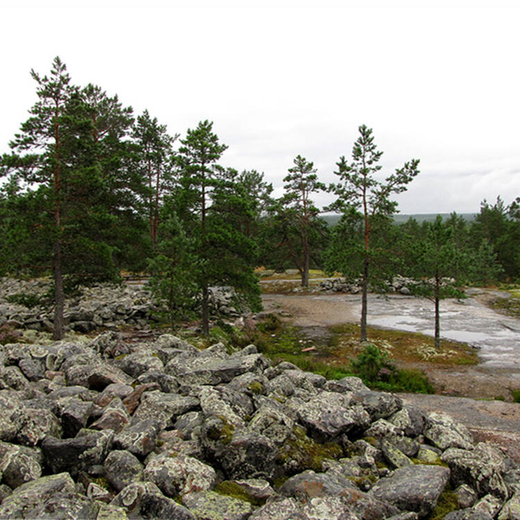
This Bronze Age burial site features more than 30 granite burial cairns, providing a unique insight into the funerary practices and social and religious structures of northern Europe more than three millennia ago.
Description is available under license CC-BY-SA IGO 3.0
Site funéraire de l'âge du bronze de Sammallahdenmäki
La trentaine de tumulus funéraires en granit du cimetière de l'âge du bronze de Sammallahdenmäki constituent un témoignage exceptionnel des pratiques funéraires et des structures sociales et religieuses de l'Europe du Nord d'il y a plus de trois millénaires.
Description is available under license CC-BY-SA IGO 3.0
مقابر سمنلهدنماكي التي تعود للعصر البرونزي
تشكّل الأبنية الحجرية فوق المقابر ذات الشكل المخروطي المصنوعة من الغرانيت والتي يُقدّر عددها بحوالي ثلاثين والعائدة للعصر البرونزي نموذجاً رائعاً للممارسات الجنائزية والبنى الاجتماعية والدينية في أوروبا الشمالية منذ ما يزيد عن ثلاثة آلاف سنة.
source: UNESCO/CPE
Description is available under license CC-BY-SA IGO 3.0
塞姆奥拉德恩青铜时代墓地遗址
考古学家在塞姆奥拉德恩青铜器时代墓葬遗址发现了30个花岗岩石冢,让人们能够深入研究3000多年前北欧地区的葬礼习俗和社会宗教体系。
source: UNESCO/CPE
Description is available under license CC-BY-SA IGO 3.0
Погребальный комплекс бронзового века Саммаллахденмяки
Погребальный комплекс бронзового века содержит более 30 гранитных надгробий-насыпей (cairns) и предоставляет уникальные свидетельства об обычаях погребения, социальных и религиозных структурах, бытовавших в Северной Европе более 3 тыс. лет назад.
source: UNESCO/CPE
Description is available under license CC-BY-SA IGO 3.0
Sitio funerario de la Edad del Bronce de Sammallahdenmäki
Este cementerio de la Edad del Bronce, que posee unos treinta túmulos funerarios de granito, constituye un testimonio incomparable de las prácticas fúnebres y las estructuras sociales y religiosas imperantes en el norte de Europa hace más de tres milenios.
source: UNESCO/CPE
Description is available under license CC-BY-SA IGO 3.0
サンマルラハデンマキの青銅器時代の石塚墳
フィンランド北部、ラッピ州。スカンディナヴィア青銅器文化は、紀元前1500年頃から紀元前500年頃まで、フィンランド沿岸地帯や沿岸諸島に花開いた。サンマルラハデンマキの埋葬地にある花崗岩の33の石塚は、3000年以上前のスカンディナヴィアの社会的・精神的構造を見事に解き明かしている。フィンランド最大のもので、このうち28の石塚は明らかに初期青銅器時代のものである。source: NFUAJ
Sammallahdenmäki, begraafplaats uit de bronstijd
Op de begraafplaats Sammallahdenmäki liggen meer dan 30 granieten graven in de vorm van steenhopen, die een uniek inzicht geven in de funeraire praktijken en sociale en religieuze structuren van Noord-Europa meer dan drie millennia geleden. De site wordt geassocieerd met rituelen ter verering van de zon. In het gebied werd veel brons gebruikt terwijl er geen koper of tin is te vinden. Deze werden verworven door middel van handel en uitwisseling. De bronstijd in Skandinavië was tussen 1.500 en 500 voor Christus.
Source: unesco.nl
Outstanding Universal Value
Brief synthesis
Situated on the Gulf of Bothnia, the Bronze Age Burial Site of Sammallahdenmäki forms the largest, most varied and complete burial site from the Scandinavian Bronze Age, 1500-500 B.C. The site includes 33 burial cairns within an area of 36 ha. The cairns are disposed in several distinct clusters along the crests and upper slopes of a long ridge. Out of eight excavated cairns, six can be dated to the Bronze Age and two to the Early Iron Age.
Stone burial cairns were typical for western Bronze Age culture. These cairns were usually constructed of granite boulders quarried from the cliff face below the crest of the ridge or collected from the site itself. The cairns can be classified into several different groups according to their shapes and sizes. Sammallahdenmäki also contains two unusual structures: one oval and elongated structure, which seems to have been enlarged in successive stages, and a large quadrangular cairn, known as the “Church Floor”, which is unique in Finland and extremely rare in Scandinavia. The cairns have no earth fill, and form landmarks on cliffs and gravel hillocks with an extensive view of the sea.
The cairns relate to a new religion, sun worship, which spread to the coastal regions of Finland from Scandinavia, and they have been a manifestation of kin group landownership, which is thought to have appeared with the introduction of farming.
Situated in a rugged, rocky landscape, the cairns bear exceptional witness to the social and religious structures of northern Europe, dating back to more than three millennia. The ancient coastline is still present on the cliffs of Sammallahdenmäki.
Criterion (iii): The Sammallahdenmäki cairn cemetery bears exceptional witness to the society of the Bronze Age of Scandinavia.
Criterion (iv): The Sammallahdenmäki cemetery is an outstanding example of Bronze Age funerary practices in Scandinavia.
Integrity
The Sammallahdenmäki Bronze Age Burial Site includes all elements and individual structures of cairns in an imposing natural setting, on a high ridge marking the former extent of Lake Saarnijärvi, surrounded by pine and spruce trees, and an agricultural landscape. The completeness of the site makes it an invaluable resource for research on the social behavior of societies of the time. Its remote location has protected it from development and the local population has taken pride in its protection.
The buffer zone includes the surrounding forests and agricultural landscape; to the west, it borders on Lake Saarnijärvi, which is defined as a protected bird sanctuary of national significance.
Authenticity
In terms of form and material, the cairns fully express the essence of the burial site of Sammallahdenmäki, as do the setting and the surrounding natural landscape.
The excavations of the cairns have been carried out in different stages, always taking into consideration scientific methods for research, mapping and documentation, to ensure careful restoration of the cairns.
Protection and management requirements
Sammallahdenmäki is fully protected under the national legislation. The site is managed by a Site Management Board, headed by the National Board of Antiquities, and involves representatives of the regional and local authorities, landowners and various stakeholders. The management and actions taken within the site and its buffer zone are in accordance with the Management Plan. Tourists are guided by signage to use the path network, which has been designed to include routes of different lengths, thus minimizing the threat to the vegetation of the site. Large numbers of tourists can cause long-term damage to the vegetation, which in turn might have a negative impact of the visual aspects of the site. The use of the path network is monitored and documented, which will allow for a timely reaction in case of deterioration.

 View photos from OUR PLACE the World Heritage collection
