Lut Desert
Lut Desert
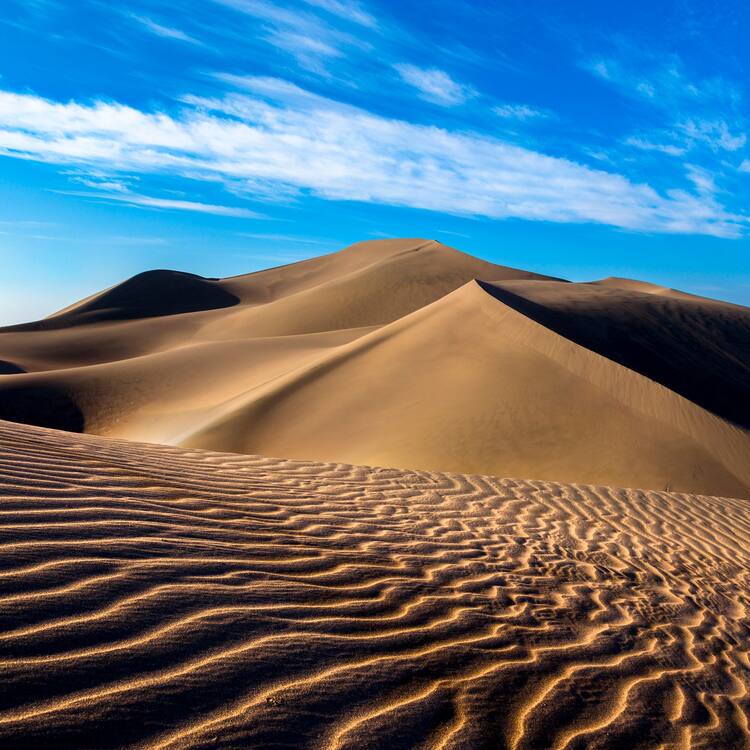
The Lut Desert, or Dasht-e-Lut, is located in the south-east of the country. Between June and October, this arid subtropical area is swept by strong winds, which transport sediment and cause aeolian erosion on a colossal scale. Consequently, the site presents some of the most spectacular examples of aeolian yardang landforms (massive corrugated ridges). It also contains extensive stony deserts and dune fields. The property represents an exceptional example of ongoing geological processes.
Description is available under license CC-BY-SA IGO 3.0
Désert de Lout
Le désert de Lout, ou Dasht-e-Lut, se trouve dans le sud-est du pays. Entre juin et octobre, cette zone subtropicale aride est balayée par des vents violents qui transportent des sédiments et provoquent une érosion éolienne à une échelle colossale. De fait, le site présente certains des exemples les plus spectaculaires de reliefs éoliens de yardangs (crêtes ondulées massives). Il se compose aussi de vastes déserts de pierre et de champs de dunes. Le bien forme un exemple exceptionnel de processus géologiques en cours.
Description is available under license CC-BY-SA IGO 3.0
صحراء لوط
تقع صحراء لوط جنوب شرق الجمهوريّة الإسلاميّة الإيرانيّة. وشهدت هذه المنطقة الرطبة شبه الاستوائيّة بين شهري حزيران/ يونيو وتشرين الأول/ اكتوبر رياحاً قويّة حاملة معها الرواسب ما أدّى إلى تعرية المكان على نطاق واسع. والمعروف أن الموقع يجسّد مثالاً مذهلاً على النقوش الناجمة عن التعرية الريحيّة مثل التلال المتموّجة. كما يوجد في الموقع صحاري صخريّة شاسعة بالإضافة إلى مساحات كبيرة من الكثبان الرمليّة. ويشكّل هذا الموقع واحداً من الأمثلة الاستثنائية على التحولات الجيولوجيّة في وقتنا الحاضر.
source: UNESCO/CPE
Description is available under license CC-BY-SA IGO 3.0
卢特沙漠
又名Dasht-e-Lut,位于伊朗东南部。在六月至十月间,这一亚热带潮湿地区经常有大风,使沉积物输送堆积,造就了大范围的风蚀景观,呈现出极为壮观的风蚀雅丹地貌(大规模起伏的垄脊),还有广袤的石漠和沙丘。这处遗产地代表了一种典型地质过程。
source: UNESCO/CPE
Description is available under license CC-BY-SA IGO 3.0
Пустыня Лут
Пустыня Лут, также известная как Деште-Лут, расположена на юго-востоке Ирана. С июня по октябрь эта влажная субтропическая зона подвержена сильным ветрам, которые вызывают масштабную ветровую эрозию и формируют осадочные отложения. В связи с этим в пустыне Лут образовались чрезвычайно живописные «ярданги» - эоловые формы рельефа, представляющие собой массивные волнообразные гребни. На территории объекта также находятся обширные каменистые пустыни и дюны. Пустыня Лут служит исключительным примером динамических геологических процессов.
source: UNESCO/CPE
Description is available under license CC-BY-SA IGO 3.0
Desierto de Lut
Situado al sudeste del país, el desierto de Lut (“Dasht-e-Lut”) es una zona subtropical húmeda azotada entre junio y septiembre por vientos de gran fuerza que transportan sedimentos y provocan una erosión eólica de proporciones colosales. En este sitio se pueden observar algunos de los más espectaculares relieves eólicos formados por crestas onduladas masivas (“yardangs”), así como vastos desiertos de piedra y un campo de dunas, que constituyen en su conjunto un ejemplo excepcional de procesos geológicos en curso de evolución.
source: UNESCO/CPE
Description is available under license CC-BY-SA IGO 3.0
ルート砂漠
多彩な表情を見せる地球上で最も暑い場所。イラン南東部に位置するルート砂漠は、70.7度の気温を記録したことがある、世界で最も暑い乾燥地の一つ。毎年6月から10月にかけて北北西の強風が吹き、その結果、世界で最も規模が大きく、壮大な波のようなヤルダン風食地形が見られ、これは宇宙からも見える。また、広大な礫砂漠や砂海もあり、さまざまな形の砂丘や海水が蒸発してできた塩原などの地形、木の周囲に砂丘が形成されたネブカと呼ばれる地形の世界最大級の例など、多様で壮観な乾燥地形が見られる場所である。source: NFUAJ
Dasht-e Lut woestijn
De Dasht-e Lut woestijn, is gelegen in het zuidoosten van Iran. Tussen juni en oktober wordt dit dorre subtropische gebied geteisterd door sterke winden die sedimenten transporteren en op kolossale schaal erosie veroorzaken. Als gevolg hiervan kent het gebied sommige van de meest spectaculaire voorbeelden van door winderosie veroorzaakte yardangs (geribbelde bergruggen). Verder bevat het gebied uitvoerige steenwoestijnen en plekken met zandduinen. De Dasht-e Lut woestijn is een toonbeeld van de voortgang van geologische processen.
Source: unesco.nl
Outstanding Universal Value
Brief synthesis
The Lut Desert is in the southeast of the Islamic Republic of Iran, an arid continental subtropical area notable for a rich variety of spectacular desert landforms. At 2,278,015 ha the area is large and is surrounded by a buffer zone of 1,794,134 ha. In the Persian language ‘Lut’ refers to bare land without water and devoid of vegetation. The property is situated in an interior basin surrounded by mountains, so it is in a rain shadow and, coupled with high temperatures, the climate is hyper-arid. The region often experiences Earth’s highest land surface temperatures: a temperature of 70.7°C has been recorded within the property.
A steep north-south pressure gradient develops across the region in spring and summer causing strong NNW-SSE winds to blow across the area between June and October each year. These long periods of strong winds propel sand grains at great velocity creating transportation of sediment and aeolian erosion on a colossal scale. Consequently, the area possesses what are considered the world’s best examples of aeolian yardang landforms, as well as extensive stony deserts and dune fields. Yardangs are bedrock features carved and streamlined by sandblasting. They cover about one third of the property and appear as massive and dramatic corrugations across the landscape with ridges and corridors oriented parallel to the dominant prevailing wind. The ridges are known as kaluts. In the Lut Desert some are up to 155 m high and their ridges can be followed for more than 40 km.
The wind also strips hard rocky outcrops bare of soil, which leaves extensive stony desert pavements (hamada) with sand-blasted faceted stones (ventifacts) across about 12% of the area. An extensive, black stony desert covers the basaltic Gandom Beryan plateau in the northwest of the core zone. The stony deserts in eastern Lut cover, as a rubbly veneer, extensive pediplains, which are rock platforms that truncate bedrock and gently slope away from the foot of neighbouring hills.
Sands transported by wind and washed in by intermittent streams have accumulated in the south and east, where huge sand-seas have formed across 40% of the property. These areas consist of active dunes some reaching heights of 475 m and are amongst the largest dunes in the world. The Lut Desert displays a wide variety of forms, including linear-, compound crescentic-, star-, and funnel-shaped dunes. Where sands are trapped around the lee of plants at the slightly wetter margins of the basin, nebkhas form to 12 m or more in height, arguably being the highest such features in the world.
Dissolved minerals evaporated from incoming streams result in white efflorescences of crystals and evaporite crusts down river beds, in yardang corridors and in salt pans (playa). Small landforms result from the pressure effects of crystal growth, including salt polygons, tepee fractured salt crusts, small salt pingos (or blisters), salt karren and gypsum domes.
The region has been described in the past as a place of ‘no life’ and information on the biological resources in this area is limited. Nevertheless the property possesses flora and fauna adapted to the harsh conditions including an interesting adapted insect fauna.
Criterion (vii): The Lut Desert protects a globally-recognized iconic hot desert landscape, one of the hottest places on earth. It is renowned for its spectacular series of landforms, namely the yardangs (massive corrugated ridges) in the west of the property and the sand-sea in the east. The yardangs are so large and impressive that they can be seen easily from space. Lut is particularly significant for the great variety of desert landform types found in a relatively small area. Key attributes of the aesthetic values of the unspoilt property relate to the diversity and sheer scale of its landforms; a visually stunning mosaic of desert colours; and uninterrupted vistas across huge and varied dune systems that transition into large flat desert pavement areas.
Criterion (viii): The property represents an exceptional example of ongoing geological processes related to erosional and depositional features in a hot desert. The yardang/kalut landforms are widely considered the best-expressed in the world in terms of extent, unbroken continuity and height. The Lut sand-seas are amongst the best developed active dune fields in the world, displaying a wide variety of dune types (crescentic ridges, star dunes, complex linear dunes, funnel-shaped dunes) with dunes amongst the highest observed anywhere on our planet. Nebkha dune fields (dunes formed around plants) are widespread with those at Lut as high as any measured elsewhere. Evaporite (salt) landforms are displayed in wide variety, including white salt-crusted crystalline riverbeds, salt pans (playa) with polygonally fractured crusts, pressure-induced tepee-fractured salt crusts, gypsum domes, small salt pingos (or blisters), and salt karren. Other dry-land landforms include extensive hamada (stony desert pavements or reg) usually located on pediment surfaces with wind faceted stones (ventifacts), gullied badlands and alluvial fans (bajada).
Integrity
Due to its remoteness from major population centres and its extreme environmental conditions, including extreme heat and lack of water, much of the Lut Desert is inaccessible and therefore naturally protected. Apart from some small private landholdings in villages in the inscribed area and buffer zone of western Lut, the majority of the land within the Lut Desert is state-owned.
Within the property, only the western edge includes settlements (there being 28 villages, the largest with just over 700 people). In the buffer zone there are 15 villages and Shahdad town with a population of nearly 6,000. The region has evidence for habitation going back 7,000 years, however this has always been around the periphery of the area, because the aridity of the property rendered most of it uninhabitable.
Knowledge on the biodiversity and ecological values of the property is limited and would benefit from greater investigation to better understand the linkages between geoheritage, biological and ecological diversity.
Protection and management requirements
The property is subject to a complex and multi-level protection regime and a range of legislation, regulations and protective mechanisms apply (14 legal instruments). Legal protection and management is provided by state level authorities that work under their specific mandates. Three agencies principally share conservation and management responsibility for the property, namely the Forests, Range and Watershed Management Organization; the Iranian Department of Environment; and the Iran Cultural Heritage, Handicrafts and Tourism Organization (ICHHTO). Protection of non-conservation lands, watershed, rangeland management and desertification is under the control of the Organization of Forests, Range and Watershed Management. This agency is responsible for the prevention of illegal exploitation of deserts. Two protected areas located in the northwest and southeast are under the management and protection of the Iranian Department of Environment. The Darband-e Ravar “wildlife refuge” in the northwest partially overlaps with the area but the Bobolab “no hunting” area in the southeast only overlaps with the buffer zone. In addition to management of the protected area, the Department of Environment is responsible for environmental assessment of development projects. The Lut Desert is also on the national heritage registration list of ICHHTO.
The property has a basic management plan at the time of inscription, which needs to be elaborated to detail threats and measures to address these; coordination arrangements for the property; specific management actions, timeframes and responsible agencies for implementation. Establishing and maintaining such a plan is an essential requirement for the protection of the property.
There is also a need to progressively build improved technical capacity to manage the natural values of the Lut Desert in light of the intrinsic links between the property’s geomorphology, geology and its desert adapted biodiversity and ecology, and the relationships to local communities and visitors. Strong measures are required to protect the property from inappropriate tourism and for off road motorized access in the long term. It is also necessary to monitor impacts and undertake restoration of degraded areas in the property, particularly in the northwest where the property includes a number of villages on the outskirts of Shadad and Anduhjerd.


