Cultural Landscape and Archaeological Remains of the Bamiyan Valley
Multiple Locations (8)
| ID | Name & Location | State Party | Coordinates | Property | Buffer Zone |
|---|---|---|---|---|---|
| 208-001 | Bamiyan Cliff including niches of the 38 meter Buddha, seated Buddhas, 55 meter Buddha and surrounding caves | Afghanistan |
N34 50 48.99 E67 49 30.89 |
105 ha | 225.25 ha |
| 208-002 | Kakrak Valley caves including the niche of the standing Buddha | Afghanistan |
N34 48 59.60 E67 51 4.90 |
15 ha | 33 ha |
| 208-003 | Qoul-I Akram Caves in the Fuladi Valley | Afghanistan |
N34 49 25.30 E67 47 53.70 |
6 ha | 40.5 ha |
| 208-004 | Kalai Ghamai Caves in the Fuladi Valley | Afghanistan |
N34 49 13.60 E67 47 14.50 |
5.5 ha | |
| 208-005 | Shahr-i-Zuhak | Afghanistan |
N34 49 34.40 E66 53 24.50 |
18 ha | 13 ha |
| 208-006 | Qallay Kaphari A | Afghanistan |
N34 48 39.50 E66 50 36.70 |
0.0625 ha | 17 ha |
| 208-007 | Qallay Kaphari B | Afghanistan |
N34 48 46.40 E66 51 0.10 |
0.064 ha | |
| 208-008 | Shahr-i-Ghulghulah | Afghanistan |
N34 49 57.60 E67 50 20.80 |
9.3 ha | 13.2 ha |
Maps
| Date | Title | |
|---|---|---|
|
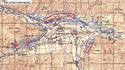
2003 | Map showing delimitations of the proposed core and buffer zones |
Disclaimer
The Nomination files produced by the States Parties are published by the World Heritage Centre at its website and/or in working documents in order to ensure transparency, access to information and to facilitate the preparations of comparative analysis by other nominating States Parties.
The sole responsibility for the content of each Nomination file lies with the State Party concerned. The publication of the Nomination file, including the maps and names, does not imply the expression of any opinion whatsoever of the World Heritage Committee or of the Secretariat of UNESCO concerning the history or legal status of any country, territory, city or area or of its boundaries.