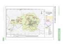
Historic Monuments and Sites in Kaesong
Multiple Locations (8)
| ID | Name & Location | State Party | Coordinates | Property | Buffer Zone |
|---|---|---|---|---|---|
| 1278rev-001 | Manwoldae & Kaesong Chomsongdae | Democratic People's Republic of Korea |
N37 59 9.28 E126 32 32.795 |
43.5 ha | 5,222.1 ha |
| 1278rev-002 | Kaesong Walls | Democratic People's Republic of Korea |
N37 59 13.927 E126 32 7.127 |
175.8 ha | |
| 1278rev-003 | Kaesong Namdae Gate | Democratic People's Republic of Korea |
N37 58 18.408 E126 33 23.342 |
0.5 ha | |
| 1278rev-004 | Koryo Songgyungwan | Democratic People's Republic of Korea |
N37 59 31.178 E126 34 14.603 |
3.5 ha | |
| 1278rev-005 | Sungyang Sowon | Democratic People's Republic of Korea |
N37 58 29.899 E126 33 40.133 |
2.9 ha | |
| 1278rev-006 | Sonjuk Bridge and Phyochung Monuments | Democratic People's Republic of Korea |
N37 58 36.988 E126 33 58.032 |
1.8 ha | |
| 1278rev-007 | Mausoleum of King Wang Kon, Seven Tombs Cluster & Myongrung Cluster | Democratic People's Republic of Korea |
N37 59 8.12 E126 30 18.731 |
214.6 ha | |
| 1278rev-008 | Mausoleum of King Kongmin | Democratic People's Republic of Korea |
N37 58 55.268 E126 28 23.837 |
51.6 ha |
Maps
Disclaimer
The Nomination files produced by the States Parties are published by the World Heritage Centre at its website and/or in working documents in order to ensure transparency, access to information and to facilitate the preparations of comparative analysis by other nominating States Parties.
The sole responsibility for the content of each Nomination file lies with the State Party concerned. The publication of the Nomination file, including the maps and names, does not imply the expression of any opinion whatsoever of the World Heritage Committee or of the Secretariat of UNESCO concerning the history or legal status of any country, territory, city or area or of its boundaries.