Stari Grad Plain
Stari Grad Plain
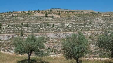
Stari Grad Plain on the Adriatic island of Hvar is a cultural landscape that has remained practically intact since it was first colonized by Ionian Greeks from Paros in the 4th century BC. The original agricultural activity of this fertile plain, mainly centring on grapes and olives, has been maintained since Greek times to the present. The site is also a natural reserve. The landscape features ancient stone walls and trims, or small stone shelters, and bears testimony to the ancient geometrical system of land division used by the ancient Greeks, the chora which has remained virtually intact over 24 centuries.
Description is available under license CC-BY-SA IGO 3.0
Plaine de Stari Grad
La plaine de Stari Grad, située sur l'île adriatique de Hvar, est un espace culturel qui est resté pratiquement intact depuis sa première colonisation par des Grecs venus de l'île égéenne de Paros au IVème siècle avant J.C. L'activité agricole originelle - basée sur la vigne et l'olivier - de cette plaine fertile s'est maintenue depuis les origines jusqu'à aujourd'hui. Le site est aussi une réserve naturelle. Le paysage, qui comprend des parcelles et des chemins délimités par des murs de pierres sèches, ainsi que des petites constructions en pierre, témoigne de l'ancien système d'organisation agricole en lots réguliers utilisé par les Grecs, la chora, qui est restée pratiquement intacte au cours de 24 siècles.
Description is available under license CC-BY-SA IGO 3.0
سهل ستاري غراد
يشكل الموقع مشهداً ثقافياً لم يتغير على الإطلاق منذ استعماره من جانب الإغريقيين في القرن الرابع قبل الميلاد. وقد حوفظ في هذا السهل الخصب على النشاط الزراعي الأصلي، بالتركيز بالأخص على العنب والزيتون، منذ الحقبة الإغريقية إلى يومنا هذا. كما يشكل الموقع محمية طبيعية. ويشمل منظره الطبيعي جدراناً حجرية قديمة ومزخرفة، وملتجآت حجرية صغيرة. كما يوفر المكان مثلاً على النظام الهندسي القديم لتقسيم الأراضي لدى الإغريقيين، والذي بقي على حاله منذ أكثر من 24 قرناً.
source: UNESCO/CPE
Description is available under license CC-BY-SA IGO 3.0
Долина Старого города
Долина Старого города, расположенная на острове Хвар в Адриатике, представляет собой культурный ландшафт, оставшийся в практически нетронутом состоянии со времен его первой колонизации в IV веке до н.э. греками с острова Парос (в Эгейском море). Традиционным видом земледелия на его плодородной земле было и остается выращивание винограда и оливок. Объект также является природным заповедником. Его территория состоит из отдельных участков, аллей с каменными стенами, а также небольших каменных построек, что свидетельствует о системе раздела земель на равные доли (греческое название раздела – шора), использовавшейся древними греками. Эта система, не претерпевшая практически никаких изменений за последние 24 столетия, применяется здесь и в наши дни.
source: UNESCO/CPE
Description is available under license CC-BY-SA IGO 3.0
La llanura de Stari Grad
En la isla de Hvar, en el Adriático, es un paisaje cultural agrícola que ha permanecido prácticamente intacto desde que fue colonizado por primera vez por griegos jónicos llegados de la isla de Paros en el siglo IV a. de C. La arquitectura original de esta fértil llanura, donde se cultivan sobre todo vides y olivos, se ha mantenido desde la época griega hasta la actualidad. Es también una reserva natural. Su paisaje incluye muros antiguos de piedra y ornamentos, como pequeños refugios de piedra que dan testimonio del antiguo sistema geométrico de división de tierras utilizado en la Antigüedad por los griegos, la chora, que ha permanecido prácticamente intacto durante más de 24 siglos.
source: UNESCO/CPE
Description is available under license CC-BY-SA IGO 3.0
スタリー・グラード平原
アドリア海のフヴァル島にあるスタリー・グラード平原は、紀元前4世紀に、パロス島出身のギリシャ人たちが農業目的で植民地化した土地。入植者たちは肥沃なこの土地を、乾いた石壁によって幾何学的に区画割し、葡萄とオリーブを植えた。以来、24世紀にわたってこの農地は葡萄とオリーブの栽培のために利用され続けており、現在もその景観が保たれている。貯蔵庫として使用された石造りの建物のほか、14世紀に造られたブロボスカ村などを登録範囲内に含むこの平原は、古代ギリシャの農業景観を、地中海世界でも良好に残す土地として、きわめて重要な意味を持っている。この平原はまた、自然保護区にも指定されている。source: NFUAJ
Stari Grad vlakte
De Stari Grad vlakte bevindt zich op het eiland Hvar. Het is een cultureel landschap dat grotendeels intact is gebleven sinds het gekoloniseerd werd door Ionische Grieken uit Paros in de 4e eeuw voor Christus. De oorspronkelijke agrarische activiteiten van deze vruchtbare vlakte – voornamelijk gericht op druiven en olijven – zijn gehandhaafd sinds de Griekse tijden tot op heden. Het gebied is ook een natuurreservaat. Het landschap beschikt over oude stenen muren en randen, en kleine stenen schuilplaatsen. Ze getuigen van het oude geometrische systeem van landverdeling dat de oude Grieken gebruikten: de chora, die al meer dan 24 eeuwen lang nagenoeg intact is gebleven.
Source: unesco.nl

Outstanding Universal Value
Stari Grad Plain represents a comprehensive system of land use and agricultural colonisation by the Greeks, in the 4th century BC. Its land organisation system, based on geometrical parcels with dry stone wall boundaries (chora), is exemplary. This system was completed from the very first by a rainwater recovery system involving the use of tanks and gutters. This testimony is of Outstanding Universal Value.
The land parcel system set up by the Greek colonisers has been respected over later periods. Agricultural activity in the chora has been uninterrupted for 24 centuries up to the present day, and is mainly based on grapes and olives.
The ensemble today constitutes the cultural landscape of a fertile cultivated plain whose territorial organisation is that of the Greek colonisation.
Criterion (ii): The land parcel system, dating from the 4th century BC, of Stari Grad Plain bears witness to the dissemination of the Greek geometrical model for the dividing up of agricultural land in the Mediterranean world.
Criterion (iii): The agricultural plain of Stari Grad has remained in continuous use, with the same initial crops being produced, for 2400 years. This bears witness to its permanency and sustainability down the centuries.
Criterion (v): The agricultural plain of Stari Grad and its environment are an example of very ancient traditional human settlement, which is today under threat from modern economic development, particularly from rural depopulation and the abandonment of traditional farming practices.
The Greek cadastral system has been fully respected during the continuous agricultural use of the plain, based on the same crops. This system is today perfectly identifiable, and has changed very little. Stari Grad Plain forms an agricultural and land use ensemble of great integrity. The authenticity of the Greek land division system known as chora is clearly in evidence throughout the plain. The built structures of the stone walls are authentic, with the same basic dry stone wall materials being used and reused since the foundation by the Greeks.
The setting up of the management plan and of the authority in charge of its application should enable the carrying out of a thorough programme of archaeological excavations, the fostering of sustainable agricultural development in the chora and the control of urban and tourism development in the vicinity of the property, with all due care being taken to ensure that its Outstanding Universal Value is respected.


The Nomination files produced by the States Parties are published by the World Heritage Centre at its website and/or in working documents in order to ensure transparency, access to information and to facilitate the preparations of comparative analysis by other nominating States Parties.
The sole responsibility for the content of each Nomination file lies with the State Party concerned. The publication of the Nomination file does not imply the expression of any opinion whatsoever of the World Heritage Committee or of the Secretariat of UNESCO concerning the history or legal status of any country, territory, city or area or of its boundaries.
Protections
by other conservation instruments
1 protection / 2 elements
2003 Convention for the Safeguarding of the Intangible Cultural Heritage (2 elements)