Agricultural Landscape of Southern Öland
Agricultural Landscape of Southern Öland
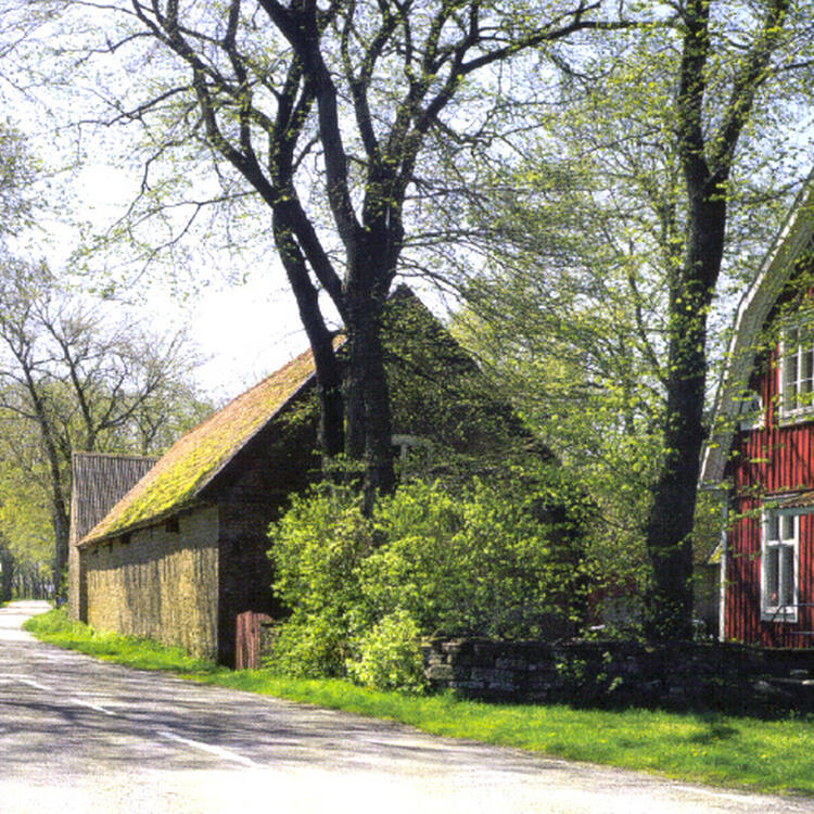
The southern part of the island of Öland in the Baltic Sea is dominated by a vast limestone plateau. Human beings have lived here for some five thousand years and adapted their way of life to the physical constraints of the island. As a consequence, the landscape is unique, with abundant evidence of continuous human settlement from prehistoric times to the present day.
Description is available under license CC-BY-SA IGO 3.0
Paysage agricole du sud d’Öland
La partie sud de l'île d'Öland, dans la mer Baltique, est dominée par un grand plateau calcaire. Les hommes vivent ici depuis quelque cinq mille ans et adaptent leur mode de vie aux contraintes physiques de l'île. Le paysage est, de ce fait, unique et témoigne abondamment d'une occupation humaine continue depuis la préhistoire jusqu'à nos jours.
Description is available under license CC-BY-SA IGO 3.0
المنظر الزراعي جنوب أولاند
تسيطر على الجزء الجنوبي من جزيرة أولاند في بحر البلطيق هضبة كلسية كبيرة. وأصبحت هذه المنطقة منذ 5000 عام مأهولة بالسكان الذي يكيّفون نمط حياتهم مع الصعوبات التي يواجهونها في الجزيرة، وهو ما يسبغ المنظر بالفرادة ويجعله شاهداً على التواجد البشري المستمر منذ عصور ما قبل التاريخ وحتى اليوم.
source: UNESCO/CPE
Description is available under license CC-BY-SA IGO 3.0
南厄兰岛的农业风景区
厄兰岛位于波罗的海,它的南部由一片巨大的石灰石高地构成。人类已经在此居住了五千年,他们的生活方式也已适应了岛上恶劣的自然环境。因此,岛上的风景显得极为独特,丰富的证据表明从史前时代到现在,一直有人类在此居住。
source: UNESCO/CPE
Description is available under license CC-BY-SA IGO 3.0
Сельский ландшафт в южной части острова Эланд
В южной части острова Эланд на Балтийском море доминирует обширное известняковое плато. Люди, жившие здесь около 5 тыс. лет назад, приспосабливались к природным условиям острова. Сформировавшийся в итоге уникальный ландшафт несет многочисленные следы проживания человека с доисторических времен и до наших дней.
source: UNESCO/CPE
Description is available under license CC-BY-SA IGO 3.0
Paisaje agrícola del sur de Öland
El sur de la isla báltica de Öland está dominado por una gran meseta calcárea en la que el hombre vive desde hace más de 5.000 años, adaptando su modo de vida a las condiciones naturales. El resultado de esa presencia humana es el excepcional paisaje del sitio, en el que abundan los testimonios de poblamientos continuos desde los tiempos prehistóricos hasta nuestros días.
source: UNESCO/CPE
Description is available under license CC-BY-SA IGO 3.0
エーランド島南部の農業景観
スウェーデンの南端近く、バルト海にあるスウェーデン第二の島エーランド島南部には、石灰岩を敷きつめた広大な道がある。この道は約5000年もの間、厳しい気候にも関わらず人類がここで生活し、自らの生活を過酷で狭隘な環境に適応させてきたことを示している。青銅器時代や鉄器時代の先史時代の墓所も見られ、今日に至るまで絶えることなく続いてきた人類の居住跡が豊富に残された、独特な景観が広がる農地である。source: NFUAJ
Agrarisch landschap van Zuid-Öland
Het zuidelijk deel van het eiland Öland in de Oostzee wordt gedomineerd door een groot kalkstenen plateau. Ongeveer vijfduizend jaar hebben hier mensen gewoond die hun manier van leven aanpasten aan de fysieke beperkingen van het eiland. Het eiland bevat een overvloed aan aanwijzingen voor continue menselijke bewoning vanaf de prehistorie tot op heden en is daarmee uniek. Zuid-Öland is een uitstekend voorbeeld van menselijke bewoning waarbij optimaal gebruik is gemaakt van de diverse landschapstypen op een eiland. De middeleeuwse verkaveling toont hoe natuurlijke omstandigheden al in een vroeg stadium de omvang van de bebouwbare oppervlakte dicteerden.
Source: unesco.nl
Outstanding Universal Value
Brief Synthesis
The southern part of Öland, an island in the Baltic Sea off the south-eastern coast of Sweden, is dominated by a vast limestone plateau. People have lived there for some five thousand years, adapting their way of life to the physical constraints of the island. As a consequence, the landscape is unique, and there is abundant evidence of a continuous human settlement from prehistoric times to the present.
This outstanding human settlement has made optimum use of diverse landscape types on a single island. Limestone bedrock and a warm, dry climate have set limits for how the islanders can use their landscape. Earlier, the land was divided into infields and pastures. The infields lay closest to the village and consisted of arable lands and meadows. The pastures – the alvar plains and the coastal lands – were used for grazing. With the transformation of agriculture in the 19th century, this distinction disappeared on the mainland and elsewhere in Europe. Instead of being part of the agricultural system, pastures were used for timber production. In Öland, barren soil ruled this out, and the old division, with linear villages in ‘lawful location’, was retained and is easily discernible today.
Southern Öland is a living agrarian landscape where villages, arable lands, coastal lands and alvar plains make up this World Heritage property. The villages are almost entirely located along Västra Landborgen, and there are a large number of archaeological sites from the prehistoric period. The present agricultural landscape and the community of southern Öland have a unique cultural tradition which still exists in land use, land division, place names, settlement and biological diversity as far back as the Iron Age. The Öland farmers, in their various everyday lives, are a necessary part (sine qua non) of the history and future of this landscape. Today, the islanders farm land which has been ploughed for generations and put livestock out to pasture on land which has been grazed for millennia – a unique situation. In order for the particular natural and cultural qualities of the property to be sustained, the future must also include a living agriculture.
Criterion (iv): The landscape of Southern Öland takes its contemporary form from its long cultural history, adapting to the physical constraints of the geology and topography.
Criterion (v): Southern Öland is an outstanding example of human settlement, making the optimum use of diverse landscape types on a single island.
Integrity
The property encompasses 56,323 ha which comprise the entire cultural landscape that demonstrates the historical land-use and land division system. The landscape is preserved in all its necessary parts and contains all the necessary attributes to convey the Outstanding Universal Value of the property. It preserves abundant traces of its long settlement history and continues to demonstrate human ingenuity and resourcefulness in utilizing a physical landscape and environment that are not at first sight favourable to human settlement and exploitation. Also, the medieval land-use pattern of villages and field systems is still clearly visible, which is a very rare survival in northern Europe.
The farmers are a living part of the contemporary lives and livelihoods of the agrarian landscape hence the integrity of this World Heritage property as a cultural landscape is fully maintained.
Authenticity
The present-day agrarian landscape is characterized by several distinct and historically significant chronological strata, which together reflect a considerable chronological depth: a) the abandoned Iron Age landscape, b) the far-reaching medieval distinction between infields and pastures, with settlements structured as villages and c) the land distribution reforms of the 18th and 19th centuries, resulting in the redistribution of holdings and the erection of stone walls to mark the boundaries between them. The functional relationship between the elements of the agricultural landscape of southern Öland is very distinct, extremely well-preserved and highly authentic. Successive protective measures have ensured the survival of the significant cultural features of southern Öland with a minimum of extraneous additions or modification. As a continuing landscape, therefore, its authenticity must be considered to be high.
Protection and management requirements
The Agricultural Landscape of Southern Öland is protected according to various Swedish statutes, most importantly the National Heritage Act, the Planning and Building Act and the Environmental Code. These safeguard the archaeological sites and monuments, historic buildings, landscape and wildlife of southern Öland. Under the terms of the Environmental Code, the entire island of Öland is designated an Area of National Interest, and several additional areas, which include much of this World Heritage property, are also designated “areas of national interest for natural and cultural values or for outdoor recreation.”
Within the World Heritage property, ownership is principally vested in a large number of private individuals and enterprises, the State and Mörbylånga Municipality. Throughout the municipality, the number of farmers has decreased from 428 to 360 between 2000 and 2010. However, no agricultural land has been taken out of production. The agricultural policy of the European Union and Sweden may have a decisive impact on the future of southern Öland. As noted before, in order for the natural and cultural attributes of the property to be sustained, the future must also include a living agriculture.
A declaration of intent regarding the property has been agreed upon by the County Administrative Board of Kalmar, the Federation of Swedish Farmers, the Regional Council of Kalmar County and Mörbylånga Municipality. The guidelines for cooperation and objectives for the World Heritage property are set out in this policy document. A management plan for this property was adopted in 2008 and includes a clarification of the division of responsibility between these parties as well as provisions for its conservation and protection.

