|
version español

by INESAU (Instituto Español de Arquitectura y Urbanismo)
In protohistoric times, the area now occupied by
the city of Valencia consisted of lagoons and flood plains,
on which tribes or families engaged in fishing are thought
to have settled. The very large lake, of which La Albufera
is a present-day vestige, presumably skirted the high ground
surrounding the cathedral, and it was there that a lakeside city,
initially built on stilts and subsequently consisting of huts,
came into being.
What might be termed the founding of the city was reported by
Titus Livius in the following words: "Year of the foundation of Rome
616. Junius Brutus, consul of Spain, gave those who had fought under
the orders of Viriathus plots of land and a city, which they called Valencia".
However, the epic struggle between Sertorius and Pompey the Great had
fatal consequences for the city, which supported Sertorius against Rome.
The outcome was the final triumph of Pompey, the death of C. Herenius
Sertorius and the destruction of his army and the city of Valencia.
During the first century A.D., Valencia re-emerged and became larger
than it had been before its destruction. Pliny the Elder refers to Valencia
as being a Roman colony situated 3,000 paces from the sea. The Roman city was
2.70 metres lower than the present-day level of the streets and was originally
situated on the south bank of the river Turia, at the point where the river
intersected with the Via Augusta, an important Roman road stretching from Italy
to Andalusia.
It has not been possible to ascertain precisely the extent or shape of
the early city, although the most widely accepted assumption is that
the initial core was round the cathedral, with the forum on the present-day
Plaza de la Virgen. Branching out from the forum were the Cardo, running
from north to south, and the Decumano, from east to west, corresponding
to Navellcs-Miguelete and Almudin-Caballeros streets. The city did not
really become important until the third century, following the destruction
of Sagunto which had been the capital of the region.
Valencia subsequently formed part of the kingdom of the Goths, although
the documents currently at our disposal do not make it possible to form
a clear picture of the history of Valencia in this period. The chronicle
of St Isidore states that "until the time of Leovigildus in the year 568,
the Goths were confined to a limited area corresponding to that of
the imperial lands extending from Andalusia to as far as Valencia".
Evidence of the incorporation of Valencia in the kingdom of the Goths
can be found in the proceedings of the councils held from 633 to 693,
which record the names of seven bishops who governed the eastern diocese
during this period.
After the Goths were overthrown at the battle of Guadalete in 711, three armies
of Moors from Africa fanned out across the peninsula. The army, led
by Tarik conquered Murviendro, Valencia, Játiva and Denia. The Moors
arrived in Valencia in 718. The new Islamic culture was established
in the city for five centuries and conferred on it a character of its own,
traces of which can still be seen.
The economy of Muslim Valencia, based on agriculture, started to grow
in the 11th century under the Moors. This period coincided with the reign of Abd al Aziz,
who was instrumental in building the Arab surrounding walls. The walled
enclosure more than covered the Roman site and occupied virtually the whole
of the island in the river Turia, although the double river channel had
disappeared by the time the walls were built. The Moorish site was three
times the size of the Roman one; it occupied an area of 47 hectares and
had some 15,000 inhabitants.
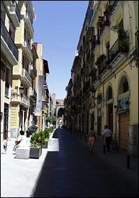
The city inside the walls was typically Islamic, with its narrow winding streets
and a large number of "atzucacs", or blind alleys. The civic centre was situated
in the old Roman enclosure. The Alcázar fortress was on the site now occupied
by the Archbishop's palace. The mosque was on the site of the present-day cathedral.
The only Moorish buildings left standing are the baths of Abd Al-Malik, now known as
the "Baños del Almirante", whose complete layout we know from Laborde's engravings.
The conquest of the city of Valencia by James I of Aragon in September 1238 gave
rise to a fundamental change of style in its development. The city was divided
into different quarters corresponding to the origins of their inhabitants.
The 1,615 houses listed in the "Libre del Repartiment" were distributed
to the new inhabitants, who came from Barcelona. The remaining Moors were
moved to the outskirts on the western side of the city, where the "Moreria"
quarter was created. The market was also built outside the walls,
where it remains to this day. Work started on converting the homes
of the early inhabitants in order to adapt them to the way of life
of their new owners. New Christian churches appeared. Gothic architecture
was introduced; in most instances in the austere Cistercian style which was
subsequently to evolve towards more elaborate forms.
The layout of the Moorish streets was not suited to Christian tastes and a
large number of regulations were adopted relating to the construction of
new buildings and the streets on which they stood, resulting in a series
of piecemeal changes rather than a new overall plan. The "atzucacs"
disappeared and the construction of protruding buildings was regulated.
The Jewish population lived in the eastern part of the city in an enclosed
quarter known as "el Call".
The first monastic buildings made their appearance. They were located all
around the original walled enclosure and situated as close as possible
to the main access roads to the capital. The emergence of these important
religious buildings was to have a fundamental influence on the subsequent
development of the city. The large number of such buildings was a feature
of Baroque Valencia and governed its urban development, since they acted
as focal points. Inside the city, public buildings were constructed,
such as El Almudin (the public granary) in 1307 and the Casa de la Ciudad,
from 1311 to 1342. The quarters of Roteros, Boatella, Xerea and Vilanova
grew up around the original walled city. Since the city continued to grow
outside the walls, it was considered necessary to extend the enclosure.
Construction work on the new wall started in 1356 and the monumental
Serranos gateway was erected between 1392 and 1393. These quarters and
the monastic buildings were included in the new enclosure.
The civic centre was set out around the Plaza de la Catedral and housed
the main governing bodies.
One major cultural event was the creation of the university, which was established
in 1498 in the south-east corner of the former Jewish quarter. A considerable number
of documents relating to the activities of "els jurats" have been preserved; these
were aimed at obtaining land through expropriation and gave rise to large-scale
projects for the construction of public buildings (the Lanja silk exchange and
the Miguelete tower).
In the 16th century, the outstanding feature of Valencia was the large number
of religious foundations, which changed the face of the city. Escolano estimates
that one third of its area was occupied by religious buildings. The road to
the sea became a major thoroughfare and opened up the city on its eastern side.
The market square continued to be the centre of commerce and provided the setting
for sporting and religious events. Valencia kept its mediaeval layout, contrasting
with the urban development requirements which the Hapsburgs imposed on other cities.
The area around the university, in particular, acquired its distinctive character.
The Corpus Christi college was established in 1586 and is one of the most important
architectural monuments of the city. One significant feature was the grouping-together
of different occupations in particular streets, which gave rise to a functional
breakdown by corporations. The original names of such streets as Correger’a,
Calderer’a, Tapiner’a and Las Barcas have come down to the present day.
Among the public works undertaken, the construction of bridges over the
river Turia was a particularly important development. In addition to
the existing Serranos bridge, the Puente del Mar bridge was built
in 1596 and the Real bridge three years later. Lists of buildings
based on contemporary treatises suggest that the most outstanding
was the San Miguel de los Reyes convent.
Valencia in the 16th century was marked by a severe economic depression
largely caused by the expulsion of the Moors, who represented 30 per cent
of the population, with all the repercussions that this entailed. Even so,
the construction of monastic buildings continued and at its height Valencia
came to be known as a city of convents and monasteries, with as many as 41
such establishments. The present-day basilica of the Mare de Deu dels Desemparats
was built between 1652 and 1667. As a result of the economic recovery in the
third quarter of the century, work on expanding the port started in 1685, but
was wiped out by a storm only a few years later.
In 1704, Tomás Vicente Tosca made a drawing in perspective of the city,
its first cartographic representation. In the first half of the 18th century,
Valencia lost its charter when it was occupied by the Bourbons. There was a short
period of economic depression, during which changes in the urban fabric were made
primarily for military reasons: the Ciudadela fortress was extended, the former
customs house was demolished and the number of gateways to the city was reduced
to four (Serranos, Real, San Vicente and Quart). In 1768, the San Carlos Royal
Academy of Fine Arts was created, advocating a neo-classical model for the city.
Above all, however, the main feature of the 18th century was the construction
of important monumental buildings, such as the customs house, which is now
occupied by the Law Courts, the Escuelas P’as and the Temple building, now
the seat of the civil governor. The boom in trade highlighted the importance
of the port. A new road, the camino del Grao, was built, later to become the
Avenida del Puerto. The river mouth was protected by breakwaters and was later
strengthened by the Levante dyke. The administrative organization of the old regime
left its mark on the city and in 1762 it was divided into four quarters - la Mar,
el Mercat, San Vicente and Serranos. The parish cemeteries were moved from inside
the city, leaving free a number of small areas within the walls which were used
to extend some streets and squares. Work started on the municipal cemetery
in 1805 and was completed two years later.
From 1808 to 1874, the city was altered and remodelled in three stages.
The first of these started with the arrival of Napoleon's troops.
Although these stayed for only a short period, the consequences
for the city were disastrous, with the destruction of the Royal Palace,
the Soledad church and the Zaldía and San Juan convents. However,
the period was also characterized by a spirit of reconciliation and
a wave of construction, especially through the opening-up of new squares
and the landscaping of a large number of urban areas. As a result of the
confiscation of property by Mendizábal, 16 monastic buildings within the
walls and 6 per cent of the urban buildings changed owners. A remarkable
and symbolic new square in a uniform architectural style, the Plaza Redonda,
was opened up in the geometric centre of the city.
The new urban concept, coupled with the possibilities for renewal offered
by expropriation, gave rise to a change in the location of urban amenities.
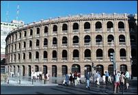
The siting of the first railway station in the orchard of the former San Francisco
convent, the construction of the bullring and the transfer of the Town Hall
from the Plaza de la Catedral to the Plaza de San Francisco marked the beginning
of the displacement of the urban centre towards the south of the city.
The third stage started following the promulgation of the urban expansion
law of 1864 after the walls had been destroyed. It was not until 1876,
when the "Urban Expansion Commission" was set up in the Municipality,
that expansion started to be a reality. This was to involve the development
of a large area of land adjacent to the old core of the city modelled on the
grid pattern designed by Ildefonso Cerdá for the expansion of Barcelona.
An attempt was made to move the city closer to the sea in 1898,
when the municipal project for the construction of the "Avenida
de Valencia al mar" was approved with the clear intention of promoting
the "garden city" concept in Valencia. This attempt ended in failure and
only a very small part of the project was carried out.
The early years of the 20th century witnessed a period of agricultural
and commercial development which resulted in the implementation
of many of the urban planning proposals put forward in the previous century.
The first of these concerned the rehabilitation of the inner city:
the opening-up of new internal roads led to significant changes in
the urban fabric of the historic centre. Secondly, the growth of the
city outside the ring road was regulated on a grid pattern based
on the plan drawn up by Francisco Mora. It did not prove possible
to extend the grid beyond the transit road and the plan was limited
to the area between the Gran Via Marqués del Tur’a and that road.
The location on the left bank of the river of the pavilions
for the regional exhibition in 1909 gave rise to considerable
development of the area between the Paseo al Mar and the river.
Other earlier proposals were taken up during the dictatorship
and, after the hiatus caused by the Civil War, urban reforms
continued in a piecemeal manner. In 1946, the Plan de Ordenación
de Valencia y su Cintura" (Plan for the Organization of Valencia
and its Surrounding Belt) was adopted, upgrading the technical
aspects of the old planning proposals of the previous century.
After the heavy floods of 1957, the "Plan Sur" was drawn up with
a view to developing a large area of land going beyond the strict
municipal boundaries of the city.
In the years that followed, uncontrolled building had an adverse impact
on the growth of the city and affected its urban planning.
The historic centre is currently the focus for an important rehabilitation
operation involving the drafting of specific planning proposals and direct
investment. Since the review of the Plan General de Ordenación Urbana
(General Urban Organization Plan), approved in 1989, Valencia has been
gearing its planning activities to its current needs.
|

|
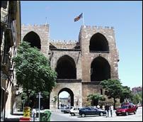
Torres de Serranos


Central Market
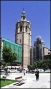
Miguelete
Bell Tower of the Seo
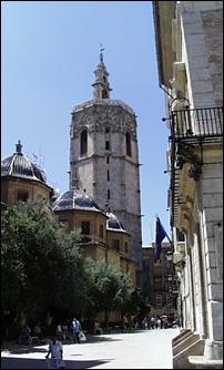
Miguelete
View from rom the Plaza de la Reina
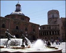
Plaza de la Virgen
Old mercantile center
Plaza de Torros
|