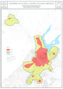
Pergame et son paysage culturel à multiples strates
Situations géographiques multiples (9)
| ID | Nom & Situation | État partie | Coordonnées | Bien | Zone tampon |
|---|---|---|---|---|---|
| 1457-001 | Pergamon, the Multi-Layered City | Türkiye |
N39 7 33.00 E27 10 48.00 |
315,46 ha | 426,928 ha |
| 1457-002 | Kybele Sanctuary at Kapikaya | Türkiye |
N39 9 55.00 E27 8 35.00 |
1,772 ha | 38,387 ha |
| 1457-003 | Ilyas Tepe Tumulus | Türkiye |
N39 7 51.07 E27 11 55.03 |
3,232 ha | |
| 1457-004 | Yigma Tepe Tumulus | Türkiye |
N39 6 15.72 E27 10 51.45 |
6,921 ha | 4,548 ha |
| 1457-005 | Ikili Tumuli | Türkiye |
N39 6 19.86 E27 10 19.98 |
0,082 ha | 0,403 ha |
| 1457-006 | Tavsan Tepe Tumulus | Türkiye |
N39 6 54.50 E27 11 40.99 |
1,245 ha | |
| 1457-007 | X Tepe Tumulus | Türkiye |
N39 6 11.88 E27 10 10.66 |
0,573 ha | 3,719 ha |
| 1457-008 | A Tepe Tumulus | Türkiye |
N39 7 0.37 E27 11 34.26 |
0,556 ha | |
| 1457-009 | Maltepe Tumulus | Türkiye |
N39 6 32.60 E27 10 21.50 |
2,741 ha | 2,935 ha |
Cartes
Les dossiers de proposition d’inscription produits par les États parties sont publiés par le Centre du patrimoine mondial sur son site Internet et/ou dans des documents de travail afin de garantir la transparence, l’accès à l’information et de faciliter la préparation d’analyses comparatives par d’autres États parties soumissionnaires.
Le contenu de chaque dossier de proposition d’inscription relève de la responsabilité exclusive de l'État partie concerné. La publication d’un dossier de proposition d’inscription, y compris les cartes et les noms, ne saurait être interprétée comme exprimant une prise de position de la part du Comité du patrimoine mondial ou du Secrétariat de l'UNESCO à propos de l’histoire ou du statut juridique d'un pays, d'un territoire, d'une ville ou d'une zone, ou de ses frontières.