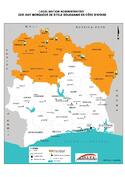
Sudanese style mosques in northern Côte d’Ivoire
Multiple Locations (8)
| ID | Name & Location | State Party | Coordinates | Property | Buffer Zone |
|---|---|---|---|---|---|
| 1648-001 | Mosquée de Tengréla | Côte d'Ivoire |
N10 29 25.15 W6 24 36.6 |
0.0081 ha | 0.0583 ha |
| 1648-002 | Mosquée de Kouto | Côte d'Ivoire |
N9 53 27.1 W6 24 50.2 |
0.0035 ha | 0.2783 ha |
| 1648-003 | Mosquée de Sorobango | Côte d'Ivoire |
N8 10 22.6 W2 42 38.49 |
0.01 ha | 0.1844 ha |
| 1648-004 | Mosquée de Samatiguila ou Missiriba | Côte d'Ivoire |
N9 49 7.89 W7 33 33.8 |
0.0411 ha | 0.1526 ha |
| 1648-005 | Mosquée de Nambira ou Namboura missiri koro | Côte d'Ivoire |
N10 7 44.3 W5 54 15.59 |
0.0076 ha | 0.1344 ha |
| 1648-006 | Grande Mosquée de Kong | Côte d'Ivoire |
N9 8 57 W4 36 34.2 |
0.0506 ha | 1.1102 ha |
| 1648-007 | Petite Mosquée de Kong | Côte d'Ivoire |
N9 08 53.2 W4 36 39.8 |
0.004 ha | 0.3769 ha |
| 1648-008 | Mosquée de Kaouara | Côte d'Ivoire |
N10 5 24.9 W5 11 41.5 |
0.0049 ha | 0.0342 ha |
Maps
Disclaimer
The Nomination files produced by the States Parties are published by the World Heritage Centre at its website and/or in working documents in order to ensure transparency, access to information and to facilitate the preparations of comparative analysis by other nominating States Parties.
The sole responsibility for the content of each Nomination file lies with the State Party concerned. The publication of the Nomination file, including the maps and names, does not imply the expression of any opinion whatsoever of the World Heritage Committee or of the Secretariat of UNESCO concerning the history or legal status of any country, territory, city or area or of its boundaries.