Saryarka – Steppe and Lakes of Northern Kazakhstan
Multiple Locations (5)
| ID | Name & Location | State Party | Coordinates | Property | Buffer Zone |
|---|---|---|---|---|---|
| 1102rev-001a | Naurzum State Nature Reserve - NSNR Main Area Naurzum - Kargay Cluster | Kazakhstan |
N51 29 10.00 E64 18 13.00 |
139,714 ha | 36,287.7 ha |
| 1102rev-001b | Naurzum State Nature Reserve – NSNR Sypsyn-Aebu Cluster | Kazakhstan |
N51 23 25.00 E63 49 21.00 |
38,720 ha | 11,624 ha |
| 1102rev-001c | Naurzum State Nature Reserve – NSNR Tersek-Karagay Cluster | Kazakhstan |
N51 47 33.00 E63 49 35.00 |
12,947 ha | 37,655.8 ha |
| 1102rev-001d | Naurzum State Nature Reserve – NSNR Eco-Corridor linking the upper cluster (only buffer zone) | Kazakhstan |
N51 37 37.99 E63 59 15 |
31,159 ha | |
| 1102rev-002 | Korgalzhyn State Nature Reserve – NSNR Cluster | Kazakhstan |
N50 25 60.00 E69 11 20.00 |
258,963 ha | 94,421 ha |
Maps
| Date | Title | |
|---|---|---|
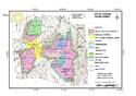
|
2007 | Saryarka – Steppe and Lakes of Northern Kazakhstan |
Disclaimer
The Nomination files produced by the States Parties are published by the World Heritage Centre at its website and/or in working documents in order to ensure transparency, access to information and to facilitate the preparations of comparative analysis by other nominating States Parties.
The sole responsibility for the content of each Nomination file lies with the State Party concerned. The publication of the Nomination file, including the maps and names, does not imply the expression of any opinion whatsoever of the World Heritage Committee or of the Secretariat of UNESCO concerning the history or legal status of any country, territory, city or area or of its boundaries.