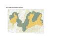
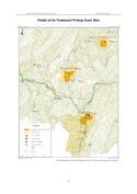
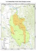
South China Karst
Multiple Locations (12)
| ID | Name & Location | State Party | Coordinates | Property | Buffer Zone |
|---|---|---|---|---|---|
| 1248bis-001 | Shilin Karst – Naigu Stone Forest | China |
N24 54 32.00 E103 21 13.00 |
1,746 ha | 22,930 ha |
| 1248bis-002 | Shilin Karst – ‘Suogeyi Village’ | China |
N24 43 4.00 E103 20 39.00 |
10,324 ha | |
| 1248bis-003 | Libo Karst – ‘Xiaoqijong’ | China |
N25 16 37.99 E107 42 51 |
7,834 ha | 43,498 ha |
| 1248bis-004 | Libo Karst – ‘Dongduo’ | China |
N25 13 8 E107 59 30.99 |
21,684 ha | |
| 1248bis-005 | Wulong Karst – Qingkou Giant Doline (Tiankeng) | China |
N29 36 8.99 E108 0 12.99 |
1,246 ha | 3,000 ha |
| 1248bis-006 | Wulong Karst – Three Natural Bridges | China |
N29 26 15 E107 47 49.99 |
2,202 ha | 4,000 ha |
| 1248bis-007 | Wulong Karst – Furong Cave | China |
N29 13 47.99 E107 54 11.99 |
2,552 ha | 25,000 ha |
| 1248bis-008 | Guilin Karst - Putao Fenling Karst Section | China |
N24 55 24.00 E110 21 16.00 |
2,840 ha | 21,610 ha |
| 1248bis-009 | Guilin Karst - Lijiang Fengcong Karst Section | China |
N25 0 8.00 E110 25 16.00 |
22,544 ha | 23,070 ha |
| 1248bis-010 | Shibing Karst | China |
N27 10 16.00 E108 5 40.00 |
10,280 ha | 18,015 ha |
| 1248bis-011 | Jinfoshan Karst | China |
N29 0 30.00 E107 11 59.00 |
6,744 ha | 10,675 ha |
| 1248bis-012 | Huanjiang Karst | China |
N25 10 1.00 E107 59 40.00 |
7,129 ha | 4,430 ha |

Disclaimer
The Nomination files produced by the States Parties are published by the World Heritage Centre at its website and/or in working documents in order to ensure transparency, access to information and to facilitate the preparations of comparative analysis by other nominating States Parties.
The sole responsibility for the content of each Nomination file lies with the State Party concerned. The publication of the Nomination file does not imply the expression of any opinion whatsoever of the World Heritage Committee or of the Secretariat of UNESCO concerning the history or legal status of any country, territory, city or area or of its boundaries.